FAQ and problem solving
This section will help you solve some problems or errors that may occur when using 3Di. Some issues are due to the software, these will be summarised in the section Known Issues, including a temporary solution. Errors related to input data or other user settings are usually covered by the schematisation checker. In rare cases however they might not catch a potential issue.
Limitations to model size
Maximum number of nodes
There is no hard limit to the size (number of nodes and flowlines) of a 3Di model. The number of nodes strongly affects the computational speed, especially in simulations where there is flow in the entire model domain (e.g. simulations with rain). Some rules of thumb can be given:
Below 100,000 nodes, no issues are to be expected and the model will generally run smoothly. If there are issues with computational speed, they are likely caused by sub-optimal choices in the schematisation of the 1D domain and/or inappropriate initial conditions.
Between 100,000 and 300,000 nodes, you may start to notice that the computational speed is affected by the number of nodes.
Between 300,000 and 500,000 nodes, the simulation will likely be slow and 3Di may run out of memory, causing the simulation to crash.
Above 500,000 nodes: it is strongly recommended to change the schematisation.
Some strategies that you can pursue to reduce the number of nodes are:
Choosing the model boundaries differently, e.g. following the hydrological watershed boundaries more precisely
Dividing the model up in multple smaller models
Choose a larger Minimum cell size and/or smaller Number of grid levels, see Model settings
Use fewer grid refinements, or increase their grid level. See Grid refinement line and ref:grid_refinement_area.
Choosing a simpler schematisation of the less important parts of the model, e.g. increase the cell size in those areas or schematise parts of the model in 1D instead of 2D. See Add 1D elements to a 2D model.
Vertical resolution
Several settings and schematisation choices control the size of the Subgrid tables. If these tables become too large, 3Di may run out of memory during the generation of the 3Di model or during the simulation. It is difficult to provide clear guidelines on this, but if you experience Internal server errors or simulation crashes with unclear reasons, this may be a cause. Have a look at the following:
Elevation range, i.e. the difference between the highest and the lowest pixel in the DEM. If the elevation range is very large, consider removing the highest parts of the model domain, e.g. replace them by Surfaces.
The table step size. If the table increments are very small and the elevation range very large, the subgrid tables may become too large.
The number of pixels per cell. If the Minimum cell size or the Number of grid levels (see Model settings) values are large and the DEM pixel size is small, there will be many pixels in one cell. This will require a large number of table increments in the subgrid tables.
Maximum raster size
The maximum size of the Digital Elevation Model is 5 billion pixels. This includes NoData pixels. The other rasters will be resampled to the resolution of the DEM, so their pixel count is not relevant.
Problem solving guide
If you run into problems, it helps to understand where you are in the modelling workflow. Try to go back to the last revision in which everything worked fine, and make small step-by-step changes, so you can pinpoint which change causes the issue. Follow the Best practices guide in your modelling workflow to prevent running into hard-to-solve issues.
Import errors in the 3Di Modeller Interface
Updating the 3Di Modeller Interface and/or its plugins may in some cases lead to import errors, for example ImportError: cannot import name ‘Dataset’ from ‘h5py’ (unknown location). The whole error will look something like this:
Couldn't load plugin 'threedi_results_analysis' due to an error when calling its classFactory() method

ImportError: cannot import name 'Dataset' from 'h5py' (unknown location)
Traceback (most recent call last):
  File "C:\PROGRA~1/3DIMOD~1.34/apps/qgis-ltr/./python\qgis\utils.py", line 423, in _startPlugin
    plugins[packageName] = package.classFactory(iface)
  File "C:\Users\user.name\AppData\Roaming\3Di\QGIS3\profiles\default/python/plugins\threedi_results_analysis\__init__.py", line 53, in classFactory
    from .threedi_plugin import ThreeDiPlugin
  File "C:\PROGRA~1/3DIMOD~1.34/apps/qgis-ltr/./python\qgis\utils.py", line 892, in _import
    mod = _builtin_import(name, globals, locals, fromlist, level)
  File "C:\Users\user.name\AppData\Roaming\3Di\QGIS3\profiles\default/python/plugins\threedi_results_analysis\threedi_plugin.py", line 10, in
    from threedi_results_analysis.processing.providers import ThreediProvider
  File "C:\PROGRA~1/3DIMOD~1.34/apps/qgis-ltr/./python\qgis\utils.py", line 892, in _import
    mod = _builtin_import(name, globals, locals, fromlist, level)
  File "C:\Users\user.name\AppData\Roaming\3Di\QGIS3\profiles\default/python/plugins\threedi_results_analysis\processing\providers.py", line 7, in
    from threedi_results_analysis.processing.cross_sectional_discharge_algorithm import CrossSectionalDischargeAlgorithm
  File "C:\PROGRA~1/3DIMOD~1.34/apps/qgis-ltr/./python\qgis\utils.py", line 892, in _import
    mod = _builtin_import(name, globals, locals, fromlist, level)
  File "C:\Users\user.name\AppData\Roaming\3Di\QGIS3\profiles\default/python/plugins\threedi_results_analysis\processing\cross_sectional_discharge_algorithm.py", line 59, in
    from threedigrid.admin.gridresultadmin import GridH5ResultAdmin
  File "C:\PROGRA~1/3DIMOD~1.34/apps/qgis-ltr/./python\qgis\utils.py", line 892, in _import
    mod = _builtin_import(name, globals, locals, fromlist, level)
  File "C:\Users\user.name\AppData\Roaming\3Di\QGIS3\profiles\default\python\plugins\threedi_results_analysis\deps\threedigrid\admin\gridresultadmin.py", line 15, in
    from threedigrid.admin.gridadmin import GridH5Admin
  File "C:\PROGRA~1/3DIMOD~1.34/apps/qgis-ltr/./python\qgis\utils.py", line 892, in _import
    mod = _builtin_import(name, globals, locals, fromlist, level)
  File "C:\Users\user.name\AppData\Roaming\3Di\QGIS3\profiles\default\python\plugins\threedi_results_analysis\deps\threedigrid\admin\gridadmin.py", line 13, in
    from threedigrid.admin.h5py_datasource import H5pyGroup
  File "C:\PROGRA~1/3DIMOD~1.34/apps/qgis-ltr/./python\qgis\utils.py", line 892, in _import
    mod = _builtin_import(name, globals, locals, fromlist, level)
  File "C:\Users\user.name\AppData\Roaming\3Di\QGIS3\profiles\default\python\plugins\threedi_results_analysis\deps\threedigrid\admin\h5py_datasource.py", line 7, in
    from h5py import Dataset
ImportError: cannot import name 'Dataset' from 'h5py' (unknown location)
If this happens right after updating any of the 3Di plugins, restarting the 3Di Modeller Interface will fix the issue in most cases.
If your installation work correctly before, but produces these errors now, make sure that the Nelen & Schuurmans Dependency Loader is activated. QGIS sometimes disables plugins after it has crashed, but the 3Di plugins will not function without the Nelen & Schuurmans Dependency Loader. Do the following:
Go to Plugins > Manage and install plugins > Installed
Find the Nelen & Schuurmans Dependency Loader in the list
Check its box to activate it
If that still does not work, the following approach should fix the issues. It is a bit of a rough remedy, but it is generally effective.
Open the user profile folder via Settings > User profiles > Open active profile folder. A Windows Explorer window will now open
Close all 3Di Modeller Interfaces you have open
In the Windows Explorer window, browse to python > plugins
- Delete the following folders:
lizard_qgis_plugin
nens_dependency_loader
threedi_models_and_simulations
threedi_results_analysis
threedi_schematisation_editor
If you get a message during the deletion that a file cannot be deleted because it is in use by qgs-ltr-bin.exe, close all QGIS processes via Ctrl+Alt+Del > Task manager and try again
Restart 3Di Modeller Interface
- Go to Plugins > Manage and install plugins > Not installed and install the following plugins:
3Di Models & Simulations
3Di Results Analysis
3Di Schematisation Editor
Lizard (if you have a Lizard subscription)
Everything should now work normally again
Errors during 3Di model generation
Run the schematisation checker. Resolve any errors reported by the checker. Also look into the warnings and info messages and try to resolve those as well, unless you are convinced that the schematisation choice for which te schematisation checker gives a warning is the correct choice for your specific use case.
Check if the 3Di Modeller Interface and the 3Di plugins are up to date. If this is not the case, update the 3Di plugins and run the schematisation checker again. It is recommended to re-install the 3Di Modeller Interface every year at the end of March.
Check if your model is not too large, see Limitations to model size
If the model generation failed while making the simulation template: Check your initial settings in your schematisation including initial (ground)water level raster.
Crashed simulations
The 3Di computational core is very stable and crashing simulations are very uncommon. Most schematisation errors that result in a failure to generate a valid 3Di model, or in crashing simulations, will be caught by the schematisation checker. However, if you do run into an error or crash, there are several things you can do to resolve the issues before contacting the Service desk. The service desk will always ask you to go through these steps before your issue is taken up.
Common causes for crashing simulations are noted in the list below. Please check these if you encounter crashing simulations.
Download the simulation logging, and check the contents of all log files. In particular:
flow_summary.json: large volume errors or NaN values indicate that the simulation has become numerically unstable (matrix convergence was impossible). You will probably find more information in matrix.log in this case.
simulation.log: if any errors are mentioned, they will probably be at/near the end of the file. But make sure to also check the rest of the file for errors or messages that may tell you more about the crash.
matrix.log: if there are any messages in this file, check if it is mentioned in the list of common error messages below, and follow the instructions for that error message.
Check if your 3Di model is up to date. The model generation will always use the latest 3Di framework, but if the 3Di model was generated a long time ago, or there was a new release after the generation of your model, your 3di Model may be outdated. Please re-generate the 3Di model to see if this resolves your issue.
If you were able to succesfully run simulations with a 3Di model of a earlier revision of the same schematisation, the problem is almost certainly caused by the recent changes you have made. Make sure you commit new revisions often and with a limited amount of changes per revision, so it is easier to pinpoint the exact cause of the problem. If your last commit included a larger number of changes, revert them one by one, and make a 3Di model for each undone change until you have a 3Di model that does run simulations succesfully.
It could be that you missed something when uploading your schematisation, when encountering a crashing simulation. You could download your schematisation and run the schematisation checker again to see if you missed any warnings.
If these suggestions did not solve your problem, you can try to run your simulation on the 3Di Live. When your model does run on 3Di Live, it could be that something is wrong with your simulation template. Check this for any weird/wrong settings and restart your simulation.
Matrix diagonal element, near zero
At one calculation point there is no storage area or the wet cross section area is near zero or even negative.
The error message indicates at which node the problem occurs. Note that the node at which the error occurs is not always the node where the schematisation problem is; in some cases it is a node near the one indicated in the error message.
The error is followed by a reference to the calculation node without any storage or link without wet cross section area. This will look something like:
Matrix diagonal element in 1D domain, near zero;nod,aii(nod) 13375 0.0000E+00
The first number (13375 in this example) refers to the calculation node on which the error occurs. To find this location:
load the computionational grid in the 3Di Modeller Interface
In the Layers panel, right-click the Node layer > Open attribute table
In the bottom left, click Show all features > Field filter > id
Type the node id that was mentioned in the error message (13375 in this example)
Select the row that is shown
In the Attribute table’s toolbar, click Zoom map to the selected rows (Ctrl-J)
This may be caused by various reasons listed below:
Structure levels are below cross-section location reference levels, for instance, a culvert’s invert levels are so far below the reference levels of the adjacent channels that the entire structure is below the river bed. This causes problems when water level drop below the channel bed level; flow through the culvert has no area to flow to. Update reference or structure levels so that they match. Reference levels can be below structure invert/crest levels.
A lateral inflow from laterals or an inflow surface is connected to a calculation node without storage, f.i. an pump end node or boundary node. Remove laterals or inflow from these nodes. Note that the storage of a calculation node is the connection node’s storage area plus the half of the storage of the adjacent channels, pipes, or culverts, see Storage in the 1D domain.
A branch of the 1D network ends with a weir or orifice (which do by definition not have storage), and the last connection node of that branch has a storage area of 0 and no boundary condition. The simulation will crash as soon as this node gets wet, either due to the initial water level, or due to water flowing towards the node.
ERROR - F - Impossible line connection at calculation node: 729
This error may occur when using embedded in combination with structures. Make sure no structure is placed entirely inside a 2D computational cell. You can only check this when you have a copy of the 2D computational grid. You can obtain this by making a purely 2D model of your DEM and grid refinement of try making one using the ‘create grid’ function in the QGIS processing toolbox.
Runtime Error: NetCDF: String match to name in use
Check the aggregation NetCDF name settings, names must be unique.
Frequently Asked Questions
My 3Di API script doesn’t work anymore, what do I need to do?
In case this is an old script (< 2022) please check the migration workflow available here.
How do I edit a simulation template?
Simulation templates cannot be edited directly. In the 3Di Modeller Interface, start a new simulation based on the template, make the desired changes, and save the simulation as a new template. When using the 3Di API, create a new simulation from the template, make the desired edits, and create a new template from the simulation.
Can I change infiltration in a simulation template?
No, infiltration is part of the schematisation. You can copy a schematisation and change the infiltration file there. An explainer on schematisations and simulation templates can be found here Schematisations, Models & Simulations
Why is the name of my simulation template ‘default’?
The name is being read from the ‘name’ attribute in the *Simulation template settings table. If that happens to be ‘default’, then that is the name of your simulation template.*
What happens if I add an extra entry in the Simulation template settings table?
Extra entries will be ignored.
I have a variant of my schematisation that I like to test, what is the best way of doing so?
Copy/clone the schematisation, make your changes and upload it as a new schematisation.
My model shows unstable behaviour, what can I do to avoid this?
First of all, instability is not common within 3Di, but certain settings or modelling choices can cause problems for the solver.
We have these tips:
Make sure you have fixed all errors and warnings that the Schematisation checker gives.
Decrease your calculation time step (background information: courant number)
Temporarily decrease your output time step . This makes it easier to analyse what goes wrong
Check if there are pumps that are pumping to another 1D node within the same 2D computational cell
Put the ‘pump_implicit_ratio’ in the numerical settings to 1. This makes sure that the model calculates smoothly for pumps (see Settings for matrix solvers –> pump_implicit_ratio)
Known issues
3Di Modeller Interface
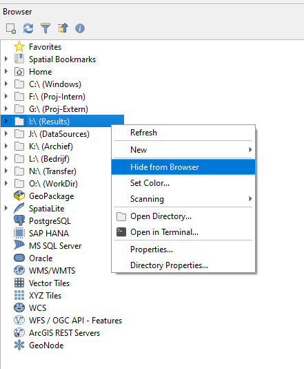
3Di Modeller Interface keeps freezing at every click
In some cases, the 3Di Modeller Interface becomes very slow to respond to everything. This is usually caused by a known QGIS issue with the Browser panel. It occurs when QGIS cannot connect to all network drives. To resolve it, hide all network drives from the browser panel, as shown in the figure below.
Interflow in the Water balance tool
The Water Balance tool does not support interflow yet. If your simulation includes interflow, the water balance may not be complete
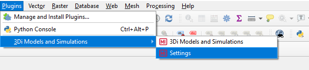
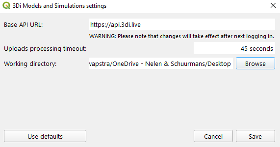
Changing the 3Di Working Directory
The 3Di working directory can be changed as follows:
Via the 3Di Models & Simulations plugin settings (see below).
3Di Modeller Interface in other languages than English
The 3Di Modeller Interface can be used in other languages than English. What matters is that the numbers notation is set to English. There is a bug in QGIS with scientific notations and Dutch number notations which can cause unexpected behaviour. This may also apply to number locations in other locales. Please go to Settings > Options > General and set Locale (numbers, date and currency formats) to en_GB.
Database is locked
In some cases the following happens: - You want to save your edits - QGIS freezes for several minutes - Finally, you see the error: “Could not commit changes to layer {layer name}. Errors: ERROR: 1 attribute value change not applied. Provider errors: OGR error committing transaction: sqlite3_exec(COMMIT) failed: database is locked”
The cause of this is probably that you have created a Query layer that uses the schematisation database that you are trying to edit as provider/source.
To resolve the issue, remove the Query layer from your project and try again.
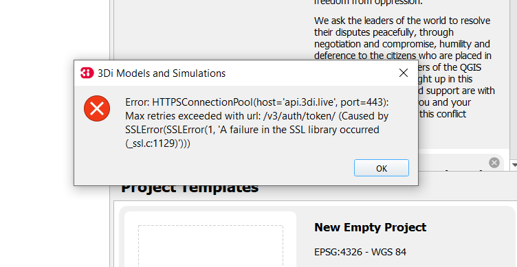
SSLError (HTTPSConnectionPool(host=’api.3di.live’, port=443): Max retries exceeded with url …)
In some cases the 3Di Models and Simulations plugin (part of the 3Di Modeller Interface) can give a generic SSLError on a Windows system (see figure below). To solve this issue, please contact your organisation’s system administrator. Instructions for your system administrator on how to solve this problem are given below the figure:
Error: HTTPSConnectionPool(host='api.3di.live', port=443): Max retries exceeded with url: /v3/auth/token/ (Caused by SSLError(1, 'A failure in the SSL Library occurred (_ssl.c:1129)')))
This error is resulting from a combination of how the plugin validates SSL/TLS certificates and how Windows expects that to happen. We are using Let’s Encrypt as our certificate supplier for most of our 3Di webservices. In September 2021 their root certificate ‘DST Root CA X3’ expired and was replaced by the ‘ISRG Root X1’ certificate. All of the Let’s Encrypt domain name certificates are issued by Intermediate Certificate ‘R3’. There are some cases where this Intermediate Certificate is still issued by ‘DST Root CA X3’, and this can create issues.
To solve this, please open a Microsoft Management Console (mmc.exe) and add the Certificates Snap-In for the user.
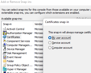
Open the “Intermediate Certification Authorities” and then the “Certificates” folder. Find the ‘R3’ Intermdiate Certificate, and check who the issuer is. If this is only ‘DST Root CA X3’, please remove it and visit https://api.3di.live/v3 with a browser.
Please contact our Service desk after this fix is applied and are still receiving the error message.
3Di Live
If a raster has a nodatavalue of 3.4028234663852886e+38 will not be visible in 3Di Live. Setting it to -9999 will solve the issue. This can be done using QGIS tooling or the following GDAL command:
gdalwarp -of GTiff -srcnodata 3.4028234663852886e+38 -dstnodata -9999 -co "COMPRESS=DEFLATE" dem1.tif dem2.tifIn rare cases the waterdepth interpolation in 3Di Live may show unexpected behaviour; it shows triangular patterns. These deviations are only visual, so the results are still correctly.
3Di Management
I can’t find the 3Di Model I am looking for
Please check the following:
Do you have access to the organisation to which the 3Di model belongs
Does the schematisation have a 3Di model? Someone may have deleted it, in which case you need to regenerate it. Go to management.3di.live, search for your schematisation and check out the details page.
List of checks run by the schematisation checker on the schematisation
These are the checks performed by the schematisation checker. The checks are listed in the order in which they are run. The beta checks are for testing purposes only, and not performed in normal usage.
Check number |
Check level |
Check message |
|---|---|---|
0001 |
Error |
boundary_condition_1d.connection_node_id refers to a non-existing connection_node |
0001 |
Error |
channel.connection_node_id_end refers to a non-existing connection_node |
0001 |
Error |
channel.connection_node_id_start refers to a non-existing connection_node |
0001 |
Error |
cross_section_location.channel_id refers to a non-existing channel |
0001 |
Error |
culvert.connection_node_id_end refers to a non-existing connection_node |
0001 |
Error |
culvert.connection_node_id_start refers to a non-existing connection_node |
0001 |
Error |
culvert.material_id refers to a non-existing material |
0001 |
Error |
dry_weather_flow.dry_weather_flow_distribution_id refers to a non-existing dry_weather_flow_distribution |
0001 |
Warning |
dry_weather_flow_map.connection_node_id refers to a non-existing connection_node |
0001 |
Warning |
dry_weather_flow_map.dry_weather_flow_id refers to a non-existing dry_weather_flow |
0001 |
Error |
exchange_line.channel_id refers to a non-existing channel |
0001 |
Error |
lateral_1d.connection_node_id refers to a non-existing connection_node |
0001 |
Error |
measure_location.connection_node_id refers to a non-existing connection_node |
0001 |
Error |
measure_map.control_id refers to a non-existing memory_control |
0001 |
Error |
measure_map.control_id refers to a non-existing table_control |
0001 |
Error |
measure_map.measure_location_id refers to a non-existing measure_location |
0001 |
Error |
memory_control.target_id refers to a non-existing channel |
0001 |
Error |
memory_control.target_id refers to a non-existing culvert |
0001 |
Error |
memory_control.target_id refers to a non-existing orifice |
0001 |
Error |
memory_control.target_id refers to a non-existing pipe |
0001 |
Error |
memory_control.target_id refers to a non-existing pump |
0001 |
Error |
memory_control.target_id refers to a non-existing weir |
0001 |
Error |
orifice.connection_node_id_end refers to a non-existing connection_node |
0001 |
Error |
orifice.connection_node_id_start refers to a non-existing connection_node |
0001 |
Error |
orifice.material_id refers to a non-existing material |
0001 |
Error |
pipe.connection_node_id_end refers to a non-existing connection_node |
0001 |
Error |
pipe.connection_node_id_start refers to a non-existing connection_node |
0001 |
Error |
pipe.material_id refers to a non-existing material |
0001 |
Error |
potential_breach.channel_id refers to a non-existing channel |
0001 |
Error |
pump.connection_node_id refers to a non-existing connection_node |
0001 |
Error |
pump_map.connection_node_id_end refers to a non-existing connection_node |
0001 |
Error |
pump_map.pump_id refers to a non-existing pump |
0001 |
Error |
surface.surface_parameters_id refers to a non-existing surface_parameters |
0001 |
Warning |
surface_map.connection_node_id refers to a non-existing connection_node |
0001 |
Warning |
surface_map.surface_id refers to a non-existing surface |
0001 |
Error |
table_control.target_id refers to a non-existing channel |
0001 |
Error |
table_control.target_id refers to a non-existing culvert |
0001 |
Error |
table_control.target_id refers to a non-existing orifice |
0001 |
Error |
table_control.target_id refers to a non-existing pipe |
0001 |
Error |
table_control.target_id refers to a non-existing pump |
0001 |
Error |
table_control.target_id refers to a non-existing weir |
0001 |
Error |
weir.connection_node_id_end refers to a non-existing connection_node |
0001 |
Error |
weir.connection_node_id_start refers to a non-existing connection_node |
0001 |
Error |
weir.material_id refers to a non-existing material |
0001 |
Error |
windshielding_1d.channel_id refers to a non-existing channel |
0002 |
Error |
aggregation_settings.id should be unique |
0002 |
Error |
boundary_condition_1d.connection_node_id should be unique |
0002 |
Error |
boundary_condition_1d.id should be unique |
0002 |
Error |
boundary_condition_2d.id should be unique |
0002 |
Error |
channel.id should be unique |
0002 |
Error |
connection_node.id should be unique |
0002 |
Error |
cross_section_location.id should be unique |
0002 |
Error |
culvert.id should be unique |
0002 |
Error |
dem_average_area.id should be unique |
0002 |
Error |
dry_weather_flow.id should be unique |
0002 |
Error |
dry_weather_flow_distribution.id should be unique |
0002 |
Error |
dry_weather_flow_map.id should be unique |
0002 |
Error |
exchange_line.id should be unique |
0002 |
Error |
grid_refinement_area.id should be unique |
0002 |
Error |
grid_refinement_line.id should be unique |
0002 |
Error |
groundwater.id should be unique |
0002 |
Error |
initial_conditions.id should be unique |
0002 |
Error |
interception.id should be unique |
0002 |
Error |
interflow.id should be unique |
0002 |
Error |
lateral_1d.id should be unique |
0002 |
Error |
lateral_2d.id should be unique |
0002 |
Error |
material.id should be unique |
0002 |
Error |
measure_location.id should be unique |
0002 |
Error |
measure_map.id should be unique |
0002 |
Error |
memory_control.id should be unique |
0002 |
Error |
model_settings.id should be unique |
0002 |
Error |
numerical_settings.id should be unique |
0002 |
Error |
obstacle.id should be unique |
0002 |
Error |
orifice.id should be unique |
0002 |
Error |
physical_settings.id should be unique |
0002 |
Error |
pipe.id should be unique |
0002 |
Error |
potential_breach.id should be unique |
0002 |
Error |
pump.id should be unique |
0002 |
Error |
pump_map.id should be unique |
0002 |
Error |
simple_infiltration.id should be unique |
0002 |
Error |
simulation_template_settings.id should be unique |
0002 |
Error |
surface.id should be unique |
0002 |
Error |
surface_map.id should be unique |
0002 |
Error |
surface_parameters.id should be unique |
0002 |
Error |
table_control.id should be unique |
0002 |
Error |
tags.id should be unique |
0002 |
Error |
time_step_settings.id should be unique |
0002 |
Error |
vegetation_drag_2d.id should be unique |
0002 |
Error |
weir.id should be unique |
0002 |
Error |
windshielding_1d.id should be unique |
0003 |
Error |
aggregation_settings.aggregation_method cannot be null |
0003 |
Error |
aggregation_settings.flow_variable cannot be null |
0003 |
Error |
aggregation_settings.id cannot be null |
0003 |
Error |
aggregation_settings.interval cannot be null |
0003 |
Error |
boundary_condition_1d.connection_node_id cannot be null |
0003 |
Error |
boundary_condition_1d.geom cannot be null |
0003 |
Error |
boundary_condition_1d.id cannot be null |
0003 |
Error |
boundary_condition_1d.time_units cannot be null |
0003 |
Error |
boundary_condition_1d.timeseries cannot be null |
0003 |
Error |
boundary_condition_1d.type cannot be null |
0003 |
Error |
boundary_condition_2d.geom cannot be null |
0003 |
Error |
boundary_condition_2d.id cannot be null |
0003 |
Error |
boundary_condition_2d.interpolate cannot be null |
0003 |
Error |
boundary_condition_2d.time_units cannot be null |
0003 |
Error |
boundary_condition_2d.timeseries cannot be null |
0003 |
Error |
boundary_condition_2d.type cannot be null |
0003 |
Error |
channel.connection_node_id_end cannot be null |
0003 |
Error |
channel.connection_node_id_start cannot be null |
0003 |
Error |
channel.exchange_type cannot be null |
0003 |
Error |
channel.geom cannot be null |
0003 |
Error |
channel.id cannot be null |
0003 |
Error |
connection_node.geom cannot be null |
0003 |
Error |
connection_node.id cannot be null |
0003 |
Error |
cross_section_location.channel_id cannot be null |
0003 |
Error |
cross_section_location.cross_section_shape cannot be null |
0003 |
Error |
cross_section_location.friction_type cannot be null |
0003 |
Error |
cross_section_location.friction_value cannot be null |
0003 |
Error |
cross_section_location.geom cannot be null |
0003 |
Error |
cross_section_location.id cannot be null |
0003 |
Error |
cross_section_location.reference_level cannot be null |
0003 |
Error |
culvert.connection_node_id_end cannot be null |
0003 |
Error |
culvert.connection_node_id_start cannot be null |
0003 |
Error |
culvert.cross_section_shape cannot be null |
0003 |
Error |
culvert.exchange_type cannot be null |
0003 |
Error |
culvert.geom cannot be null |
0003 |
Error |
culvert.id cannot be null |
0003 |
Error |
culvert.invert_level_end cannot be null |
0003 |
Error |
culvert.invert_level_start cannot be null |
0003 |
Error |
dem_average_area.geom cannot be null |
0003 |
Error |
dem_average_area.id cannot be null |
0003 |
Error |
dry_weather_flow.daily_total cannot be null |
0003 |
Error |
dry_weather_flow.dry_weather_flow_distribution_id cannot be null |
0003 |
Error |
dry_weather_flow.geom cannot be null |
0003 |
Error |
dry_weather_flow.id cannot be null |
0003 |
Error |
dry_weather_flow.multiplier cannot be null |
0003 |
Error |
dry_weather_flow_distribution.distribution cannot be null |
0003 |
Error |
dry_weather_flow_distribution.id cannot be null |
0003 |
Error |
dry_weather_flow_map.connection_node_id cannot be null |
0003 |
Error |
dry_weather_flow_map.dry_weather_flow_id cannot be null |
0003 |
Error |
dry_weather_flow_map.geom cannot be null |
0003 |
Error |
dry_weather_flow_map.id cannot be null |
0003 |
Error |
dry_weather_flow_map.percentage cannot be null |
0003 |
Error |
exchange_line.channel_id cannot be null |
0003 |
Error |
exchange_line.geom cannot be null |
0003 |
Error |
exchange_line.id cannot be null |
0003 |
Error |
grid_refinement_area.geom cannot be null |
0003 |
Error |
grid_refinement_area.grid_level cannot be null |
0003 |
Error |
grid_refinement_area.id cannot be null |
0003 |
Error |
grid_refinement_line.geom cannot be null |
0003 |
Error |
grid_refinement_line.grid_level cannot be null |
0003 |
Error |
grid_refinement_line.id cannot be null |
0003 |
Error |
groundwater.id cannot be null |
0003 |
Error |
initial_conditions.id cannot be null |
0003 |
Error |
interception.id cannot be null |
0003 |
Error |
interflow.id cannot be null |
0003 |
Error |
lateral_1d.connection_node_id cannot be null |
0003 |
Error |
lateral_1d.geom cannot be null |
0003 |
Error |
lateral_1d.id cannot be null |
0003 |
Error |
lateral_1d.time_units cannot be null |
0003 |
Error |
lateral_1d.timeseries cannot be null |
0003 |
Error |
lateral_1d.units cannot be null |
0003 |
Error |
lateral_2d.geom cannot be null |
0003 |
Error |
lateral_2d.id cannot be null |
0003 |
Error |
lateral_2d.time_units cannot be null |
0003 |
Error |
lateral_2d.timeseries cannot be null |
0003 |
Error |
lateral_2d.type cannot be null |
0003 |
Error |
lateral_2d.units cannot be null |
0003 |
Error |
material.friction_coefficient cannot be null |
0003 |
Error |
material.friction_type cannot be null |
0003 |
Error |
material.id cannot be null |
0003 |
Error |
measure_location.connection_node_id cannot be null |
0003 |
Error |
measure_location.geom cannot be null |
0003 |
Error |
measure_location.id cannot be null |
0003 |
Error |
measure_location.measure_variable cannot be null |
0003 |
Error |
measure_map.control_id cannot be null |
0003 |
Error |
measure_map.control_type cannot be null |
0003 |
Error |
measure_map.geom cannot be null |
0003 |
Error |
measure_map.id cannot be null |
0003 |
Error |
measure_map.measure_location_id cannot be null |
0003 |
Error |
measure_map.weight cannot be null |
0003 |
Error |
memory_control.action_type cannot be null |
0003 |
Error |
memory_control.action_value_1 cannot be null |
0003 |
Error |
memory_control.geom cannot be null |
0003 |
Error |
memory_control.id cannot be null |
0003 |
Error |
memory_control.lower_threshold cannot be null |
0003 |
Error |
memory_control.target_id cannot be null |
0003 |
Error |
memory_control.target_type cannot be null |
0003 |
Error |
memory_control.upper_threshold cannot be null |
0003 |
Error |
model_settings.id cannot be null |
0003 |
Error |
model_settings.node_open_water_detection cannot be null |
0003 |
Error |
numerical_settings.id cannot be null |
0003 |
Error |
obstacle.crest_level cannot be null |
0003 |
Error |
obstacle.geom cannot be null |
0003 |
Error |
obstacle.id cannot be null |
0003 |
Error |
orifice.connection_node_id_end cannot be null |
0003 |
Error |
orifice.connection_node_id_start cannot be null |
0003 |
Error |
orifice.crest_level cannot be null |
0003 |
Error |
orifice.crest_type cannot be null |
0003 |
Error |
orifice.cross_section_shape cannot be null |
0003 |
Error |
orifice.geom cannot be null |
0003 |
Error |
orifice.id cannot be null |
0003 |
Error |
physical_settings.id cannot be null |
0003 |
Error |
pipe.connection_node_id_end cannot be null |
0003 |
Error |
pipe.connection_node_id_start cannot be null |
0003 |
Error |
pipe.cross_section_shape cannot be null |
0003 |
Error |
pipe.exchange_type cannot be null |
0003 |
Error |
pipe.geom cannot be null |
0003 |
Error |
pipe.id cannot be null |
0003 |
Error |
pipe.invert_level_end cannot be null |
0003 |
Error |
pipe.invert_level_start cannot be null |
0003 |
Error |
potential_breach.channel_id cannot be null |
0003 |
Error |
potential_breach.geom cannot be null |
0003 |
Error |
potential_breach.id cannot be null |
0003 |
Error |
potential_breach.initial_exchange_level cannot be null |
0003 |
Error |
pump.capacity cannot be null |
0003 |
Error |
pump.connection_node_id cannot be null |
0003 |
Error |
pump.geom cannot be null |
0003 |
Error |
pump.id cannot be null |
0003 |
Error |
pump.lower_stop_level cannot be null |
0003 |
Error |
pump.start_level cannot be null |
0003 |
Error |
pump.type cannot be null |
0003 |
Error |
pump_map.connection_node_id_end cannot be null |
0003 |
Error |
pump_map.geom cannot be null |
0003 |
Error |
pump_map.id cannot be null |
0003 |
Error |
pump_map.pump_id cannot be null |
0003 |
Error |
simple_infiltration.id cannot be null |
0003 |
Error |
simulation_template_settings.id cannot be null |
0003 |
Error |
surface.area cannot be null |
0003 |
Error |
surface.id cannot be null |
0003 |
Error |
surface.surface_parameters_id cannot be null |
0003 |
Error |
surface_map.connection_node_id cannot be null |
0003 |
Error |
surface_map.geom cannot be null |
0003 |
Error |
surface_map.id cannot be null |
0003 |
Error |
surface_map.percentage cannot be null |
0003 |
Error |
surface_map.surface_id cannot be null |
0003 |
Error |
surface_parameters.id cannot be null |
0003 |
Error |
surface_parameters.infiltration cannot be null |
0003 |
Error |
surface_parameters.infiltration_decay_constant cannot be null |
0003 |
Error |
surface_parameters.infiltration_recovery_constant cannot be null |
0003 |
Error |
surface_parameters.max_infiltration_capacity cannot be null |
0003 |
Error |
surface_parameters.min_infiltration_capacity cannot be null |
0003 |
Error |
surface_parameters.outflow_delay cannot be null |
0003 |
Error |
surface_parameters.surface_layer_thickness cannot be null |
0003 |
Error |
table_control.action_table cannot be null |
0003 |
Error |
table_control.action_type cannot be null |
0003 |
Error |
table_control.geom cannot be null |
0003 |
Error |
table_control.id cannot be null |
0003 |
Error |
table_control.measure_operator cannot be null |
0003 |
Error |
table_control.target_id cannot be null |
0003 |
Error |
table_control.target_type cannot be null |
0003 |
Error |
tags.id cannot be null |
0003 |
Error |
time_step_settings.id cannot be null |
0003 |
Error |
vegetation_drag_2d.id cannot be null |
0003 |
Error |
weir.connection_node_id_end cannot be null |
0003 |
Error |
weir.connection_node_id_start cannot be null |
0003 |
Error |
weir.crest_level cannot be null |
0003 |
Error |
weir.crest_type cannot be null |
0003 |
Error |
weir.cross_section_shape cannot be null |
0003 |
Error |
weir.geom cannot be null |
0003 |
Error |
weir.id cannot be null |
0003 |
Error |
windshielding_1d.channel_id cannot be null |
0003 |
Error |
windshielding_1d.geom cannot be null |
0003 |
Error |
windshielding_1d.id cannot be null |
0004 |
Error |
aggregation_settings.aggregation_method is not of type [‘text’] |
0004 |
Error |
aggregation_settings.flow_variable is not of type [‘text’] |
0004 |
Error |
aggregation_settings.id is not of type [‘integer’] |
0004 |
Error |
aggregation_settings.interval is not of type [‘integer’] |
0004 |
Error |
boundary_condition_1d.code is not of type [‘text’] |
0004 |
Error |
boundary_condition_1d.connection_node_id is not of type [‘integer’] |
0004 |
Error |
boundary_condition_1d.display_name is not of type [‘text’] |
0004 |
Error |
boundary_condition_1d.geom is not of type [‘blob’] |
0004 |
Error |
boundary_condition_1d.id is not of type [‘integer’] |
0004 |
Error |
boundary_condition_1d.interpolate is not of type [‘integer’] |
0004 |
Error |
boundary_condition_1d.tags is not of type [‘text’] |
0004 |
Error |
boundary_condition_1d.time_units is not of type [‘text’] |
0004 |
Error |
boundary_condition_1d.timeseries is not of type [‘text’] |
0004 |
Error |
boundary_condition_1d.type is not of type [‘integer’] |
0004 |
Error |
boundary_condition_2d.code is not of type [‘text’] |
0004 |
Error |
boundary_condition_2d.display_name is not of type [‘text’] |
0004 |
Error |
boundary_condition_2d.geom is not of type [‘blob’] |
0004 |
Error |
boundary_condition_2d.id is not of type [‘integer’] |
0004 |
Error |
boundary_condition_2d.interpolate is not of type [‘integer’] |
0004 |
Error |
boundary_condition_2d.tags is not of type [‘text’] |
0004 |
Error |
boundary_condition_2d.time_units is not of type [‘text’] |
0004 |
Error |
boundary_condition_2d.timeseries is not of type [‘text’] |
0004 |
Error |
boundary_condition_2d.type is not of type [‘integer’] |
0004 |
Error |
channel.calculation_point_distance is not of type [‘integer’, ‘numeric’, ‘real’] |
0004 |
Error |
channel.code is not of type [‘text’] |
0004 |
Error |
channel.connection_node_id_end is not of type [‘integer’] |
0004 |
Error |
channel.connection_node_id_start is not of type [‘integer’] |
0004 |
Error |
channel.display_name is not of type [‘text’] |
0004 |
Error |
channel.exchange_thickness is not of type [‘integer’, ‘numeric’, ‘real’] |
0004 |
Error |
channel.exchange_type is not of type [‘integer’] |
0004 |
Error |
channel.geom is not of type [‘blob’] |
0004 |
Error |
channel.hydraulic_conductivity_in is not of type [‘integer’, ‘numeric’, ‘real’] |
0004 |
Error |
channel.hydraulic_conductivity_out is not of type [‘integer’, ‘numeric’, ‘real’] |
0004 |
Error |
channel.id is not of type [‘integer’] |
0004 |
Error |
channel.tags is not of type [‘text’] |
0004 |
Error |
connection_node.bottom_level is not of type [‘integer’, ‘numeric’, ‘real’] |
0004 |
Error |
connection_node.code is not of type [‘text’] |
0004 |
Error |
connection_node.display_name is not of type [‘text’] |
0004 |
Error |
connection_node.exchange_level is not of type [‘integer’, ‘numeric’, ‘real’] |
0004 |
Error |
connection_node.exchange_thickness is not of type [‘integer’, ‘numeric’, ‘real’] |
0004 |
Error |
connection_node.exchange_type is not of type [‘integer’] |
0004 |
Error |
connection_node.geom is not of type [‘blob’] |
0004 |
Error |
connection_node.hydraulic_conductivity_in is not of type [‘integer’, ‘numeric’, ‘real’] |
0004 |
Error |
connection_node.hydraulic_conductivity_out is not of type [‘integer’, ‘numeric’, ‘real’] |
0004 |
Error |
connection_node.id is not of type [‘integer’] |
0004 |
Error |
connection_node.initial_water_level is not of type [‘integer’, ‘numeric’, ‘real’] |
0004 |
Error |
connection_node.manhole_surface_level is not of type [‘integer’, ‘numeric’, ‘real’] |
0004 |
Error |
connection_node.storage_area is not of type [‘integer’, ‘numeric’, ‘real’] |
0004 |
Error |
connection_node.tags is not of type [‘text’] |
0004 |
Error |
connection_node.visualisation is not of type [‘integer’] |
0004 |
Error |
cross_section_location.bank_level is not of type [‘integer’, ‘numeric’, ‘real’] |
0004 |
Error |
cross_section_location.channel_id is not of type [‘integer’] |
0004 |
Error |
cross_section_location.code is not of type [‘text’] |
0004 |
Error |
cross_section_location.cross_section_friction_values is not of type [‘text’] |
0004 |
Error |
cross_section_location.cross_section_height is not of type [‘integer’, ‘numeric’, ‘real’] |
0004 |
Error |
cross_section_location.cross_section_shape is not of type [‘integer’] |
0004 |
Error |
cross_section_location.cross_section_table is not of type [‘text’] |
0004 |
Error |
cross_section_location.cross_section_vegetation_table is not of type [‘text’] |
0004 |
Error |
cross_section_location.cross_section_width is not of type [‘integer’, ‘numeric’, ‘real’] |
0004 |
Error |
cross_section_location.display_name is not of type [‘text’] |
0004 |
Error |
cross_section_location.friction_type is not of type [‘integer’] |
0004 |
Error |
cross_section_location.friction_value is not of type [‘integer’, ‘numeric’, ‘real’] |
0004 |
Error |
cross_section_location.geom is not of type [‘blob’] |
0004 |
Error |
cross_section_location.id is not of type [‘integer’] |
0004 |
Error |
cross_section_location.reference_level is not of type [‘integer’, ‘numeric’, ‘real’] |
0004 |
Error |
cross_section_location.tags is not of type [‘text’] |
0004 |
Error |
cross_section_location.vegetation_drag_coefficient is not of type [‘integer’, ‘numeric’, ‘real’] |
0004 |
Error |
cross_section_location.vegetation_height is not of type [‘integer’, ‘numeric’, ‘real’] |
0004 |
Error |
cross_section_location.vegetation_stem_density is not of type [‘integer’, ‘numeric’, ‘real’] |
0004 |
Error |
cross_section_location.vegetation_stem_diameter is not of type [‘integer’, ‘numeric’, ‘real’] |
0004 |
Error |
culvert.calculation_point_distance is not of type [‘integer’, ‘numeric’, ‘real’] |
0004 |
Error |
culvert.code is not of type [‘text’] |
0004 |
Error |
culvert.connection_node_id_end is not of type [‘integer’] |
0004 |
Error |
culvert.connection_node_id_start is not of type [‘integer’] |
0004 |
Error |
culvert.cross_section_height is not of type [‘integer’, ‘numeric’, ‘real’] |
0004 |
Error |
culvert.cross_section_shape is not of type [‘integer’] |
0004 |
Error |
culvert.cross_section_table is not of type [‘text’] |
0004 |
Error |
culvert.cross_section_width is not of type [‘integer’, ‘numeric’, ‘real’] |
0004 |
Error |
culvert.discharge_coefficient_negative is not of type [‘integer’, ‘numeric’, ‘real’] |
0004 |
Error |
culvert.discharge_coefficient_positive is not of type [‘integer’, ‘numeric’, ‘real’] |
0004 |
Error |
culvert.display_name is not of type [‘text’] |
0004 |
Error |
culvert.exchange_type is not of type [‘integer’] |
0004 |
Error |
culvert.friction_type is not of type [‘integer’] |
0004 |
Error |
culvert.friction_value is not of type [‘integer’, ‘numeric’, ‘real’] |
0004 |
Error |
culvert.geom is not of type [‘blob’] |
0004 |
Error |
culvert.id is not of type [‘integer’] |
0004 |
Error |
culvert.invert_level_end is not of type [‘integer’, ‘numeric’, ‘real’] |
0004 |
Error |
culvert.invert_level_start is not of type [‘integer’, ‘numeric’, ‘real’] |
0004 |
Error |
culvert.material_id is not of type [‘integer’] |
0004 |
Error |
culvert.tags is not of type [‘text’] |
0004 |
Error |
dem_average_area.code is not of type [‘text’] |
0004 |
Error |
dem_average_area.display_name is not of type [‘text’] |
0004 |
Error |
dem_average_area.geom is not of type [‘blob’] |
0004 |
Error |
dem_average_area.id is not of type [‘integer’] |
0004 |
Error |
dem_average_area.tags is not of type [‘text’] |
0004 |
Error |
dry_weather_flow.code is not of type [‘text’] |
0004 |
Error |
dry_weather_flow.daily_total is not of type [‘integer’, ‘numeric’, ‘real’] |
0004 |
Error |
dry_weather_flow.display_name is not of type [‘text’] |
0004 |
Error |
dry_weather_flow.dry_weather_flow_distribution_id is not of type [‘integer’] |
0004 |
Error |
dry_weather_flow.geom is not of type [‘blob’] |
0004 |
Error |
dry_weather_flow.id is not of type [‘integer’] |
0004 |
Error |
dry_weather_flow.interpolate is not of type [‘integer’] |
0004 |
Error |
dry_weather_flow.multiplier is not of type [‘integer’, ‘numeric’, ‘real’] |
0004 |
Error |
dry_weather_flow.tags is not of type [‘text’] |
0004 |
Error |
dry_weather_flow_distribution.description is not of type [‘text’] |
0004 |
Error |
dry_weather_flow_distribution.distribution is not of type [‘text’] |
0004 |
Error |
dry_weather_flow_distribution.id is not of type [‘integer’] |
0004 |
Error |
dry_weather_flow_distribution.tags is not of type [‘text’] |
0004 |
Error |
dry_weather_flow_map.code is not of type [‘text’] |
0004 |
Error |
dry_weather_flow_map.connection_node_id is not of type [‘integer’] |
0004 |
Error |
dry_weather_flow_map.display_name is not of type [‘text’] |
0004 |
Error |
dry_weather_flow_map.dry_weather_flow_id is not of type [‘integer’] |
0004 |
Error |
dry_weather_flow_map.geom is not of type [‘blob’] |
0004 |
Error |
dry_weather_flow_map.id is not of type [‘integer’] |
0004 |
Error |
dry_weather_flow_map.percentage is not of type [‘integer’, ‘numeric’, ‘real’] |
0004 |
Error |
dry_weather_flow_map.tags is not of type [‘text’] |
0004 |
Error |
exchange_line.channel_id is not of type [‘integer’] |
0004 |
Error |
exchange_line.code is not of type [‘text’] |
0004 |
Error |
exchange_line.display_name is not of type [‘text’] |
0004 |
Error |
exchange_line.exchange_level is not of type [‘integer’, ‘numeric’, ‘real’] |
0004 |
Error |
exchange_line.geom is not of type [‘blob’] |
0004 |
Error |
exchange_line.id is not of type [‘integer’] |
0004 |
Error |
exchange_line.tags is not of type [‘text’] |
0004 |
Error |
grid_refinement_area.code is not of type [‘text’] |
0004 |
Error |
grid_refinement_area.display_name is not of type [‘text’] |
0004 |
Error |
grid_refinement_area.geom is not of type [‘blob’] |
0004 |
Error |
grid_refinement_area.grid_level is not of type [‘integer’] |
0004 |
Error |
grid_refinement_area.id is not of type [‘integer’] |
0004 |
Error |
grid_refinement_area.tags is not of type [‘text’] |
0004 |
Error |
grid_refinement_line.code is not of type [‘text’] |
0004 |
Error |
grid_refinement_line.display_name is not of type [‘text’] |
0004 |
Error |
grid_refinement_line.geom is not of type [‘blob’] |
0004 |
Error |
grid_refinement_line.grid_level is not of type [‘integer’] |
0004 |
Error |
grid_refinement_line.id is not of type [‘integer’] |
0004 |
Error |
grid_refinement_line.tags is not of type [‘text’] |
0004 |
Error |
groundwater.equilibrium_infiltration_rate is not of type [‘integer’, ‘numeric’, ‘real’] |
0004 |
Error |
groundwater.equilibrium_infiltration_rate_aggregation is not of type [‘integer’] |
0004 |
Error |
groundwater.equilibrium_infiltration_rate_file is not of type [‘text’] |
0004 |
Error |
groundwater.groundwater_hydraulic_conductivity is not of type [‘integer’, ‘numeric’, ‘real’] |
0004 |
Error |
groundwater.groundwater_hydraulic_conductivity_aggregation is not of type [‘integer’] |
0004 |
Error |
groundwater.groundwater_hydraulic_conductivity_file is not of type [‘text’] |
0004 |
Error |
groundwater.groundwater_impervious_layer_level is not of type [‘integer’, ‘numeric’, ‘real’] |
0004 |
Error |
groundwater.groundwater_impervious_layer_level_aggregation is not of type [‘integer’] |
0004 |
Error |
groundwater.groundwater_impervious_layer_level_file is not of type [‘text’] |
0004 |
Error |
groundwater.id is not of type [‘integer’] |
0004 |
Error |
groundwater.infiltration_decay_period is not of type [‘integer’, ‘numeric’, ‘real’] |
0004 |
Error |
groundwater.infiltration_decay_period_aggregation is not of type [‘integer’] |
0004 |
Error |
groundwater.infiltration_decay_period_file is not of type [‘text’] |
0004 |
Error |
groundwater.initial_infiltration_rate is not of type [‘integer’, ‘numeric’, ‘real’] |
0004 |
Error |
groundwater.initial_infiltration_rate_aggregation is not of type [‘integer’] |
0004 |
Error |
groundwater.initial_infiltration_rate_file is not of type [‘text’] |
0004 |
Error |
groundwater.leakage is not of type [‘integer’, ‘numeric’, ‘real’] |
0004 |
Error |
groundwater.leakage_file is not of type [‘text’] |
0004 |
Error |
groundwater.phreatic_storage_capacity is not of type [‘integer’, ‘numeric’, ‘real’] |
0004 |
Error |
groundwater.phreatic_storage_capacity_aggregation is not of type [‘integer’] |
0004 |
Error |
groundwater.phreatic_storage_capacity_file is not of type [‘text’] |
0004 |
Error |
initial_conditions.id is not of type [‘integer’] |
0004 |
Error |
initial_conditions.initial_groundwater_level is not of type [‘integer’, ‘numeric’, ‘real’] |
0004 |
Error |
initial_conditions.initial_groundwater_level_aggregation is not of type [‘integer’] |
0004 |
Error |
initial_conditions.initial_groundwater_level_file is not of type [‘text’] |
0004 |
Error |
initial_conditions.initial_water_level is not of type [‘integer’, ‘numeric’, ‘real’] |
0004 |
Error |
initial_conditions.initial_water_level_aggregation is not of type [‘integer’] |
0004 |
Error |
initial_conditions.initial_water_level_file is not of type [‘text’] |
0004 |
Error |
interception.id is not of type [‘integer’] |
0004 |
Error |
interception.interception is not of type [‘integer’, ‘numeric’, ‘real’] |
0004 |
Error |
interception.interception_file is not of type [‘text’] |
0004 |
Error |
interflow.hydraulic_conductivity is not of type [‘integer’, ‘numeric’, ‘real’] |
0004 |
Error |
interflow.hydraulic_conductivity_file is not of type [‘text’] |
0004 |
Error |
interflow.id is not of type [‘integer’] |
0004 |
Error |
interflow.impervious_layer_elevation is not of type [‘integer’, ‘numeric’, ‘real’] |
0004 |
Error |
interflow.interflow_type is not of type [‘integer’] |
0004 |
Error |
interflow.porosity is not of type [‘integer’, ‘numeric’, ‘real’] |
0004 |
Error |
interflow.porosity_file is not of type [‘text’] |
0004 |
Error |
interflow.porosity_layer_thickness is not of type [‘integer’, ‘numeric’, ‘real’] |
0004 |
Error |
lateral_1d.code is not of type [‘text’] |
0004 |
Error |
lateral_1d.connection_node_id is not of type [‘integer’] |
0004 |
Error |
lateral_1d.display_name is not of type [‘text’] |
0004 |
Error |
lateral_1d.geom is not of type [‘blob’] |
0004 |
Error |
lateral_1d.id is not of type [‘integer’] |
0004 |
Error |
lateral_1d.interpolate is not of type [‘integer’] |
0004 |
Error |
lateral_1d.offset is not of type [‘integer’] |
0004 |
Error |
lateral_1d.tags is not of type [‘text’] |
0004 |
Error |
lateral_1d.time_units is not of type [‘text’] |
0004 |
Error |
lateral_1d.timeseries is not of type [‘text’] |
0004 |
Error |
lateral_1d.units is not of type [‘text’] |
0004 |
Error |
lateral_2d.code is not of type [‘text’] |
0004 |
Error |
lateral_2d.display_name is not of type [‘text’] |
0004 |
Error |
lateral_2d.geom is not of type [‘blob’] |
0004 |
Error |
lateral_2d.id is not of type [‘integer’] |
0004 |
Error |
lateral_2d.interpolate is not of type [‘integer’] |
0004 |
Error |
lateral_2d.offset is not of type [‘integer’] |
0004 |
Error |
lateral_2d.tags is not of type [‘text’] |
0004 |
Error |
lateral_2d.time_units is not of type [‘text’] |
0004 |
Error |
lateral_2d.timeseries is not of type [‘text’] |
0004 |
Error |
lateral_2d.type is not of type [‘integer’] |
0004 |
Error |
lateral_2d.units is not of type [‘text’] |
0004 |
Error |
material.description is not of type [‘text’] |
0004 |
Error |
material.friction_coefficient is not of type [‘integer’, ‘numeric’, ‘real’] |
0004 |
Error |
material.friction_type is not of type [‘integer’] |
0004 |
Error |
material.id is not of type [‘integer’] |
0004 |
Error |
measure_location.code is not of type [‘text’] |
0004 |
Error |
measure_location.connection_node_id is not of type [‘integer’] |
0004 |
Error |
measure_location.display_name is not of type [‘text’] |
0004 |
Error |
measure_location.geom is not of type [‘blob’] |
0004 |
Error |
measure_location.id is not of type [‘integer’] |
0004 |
Error |
measure_location.measure_variable is not of type [‘text’] |
0004 |
Error |
measure_location.tags is not of type [‘text’] |
0004 |
Error |
measure_map.code is not of type [‘text’] |
0004 |
Error |
measure_map.control_id is not of type [‘integer’] |
0004 |
Error |
measure_map.control_type is not of type [‘text’] |
0004 |
Error |
measure_map.display_name is not of type [‘text’] |
0004 |
Error |
measure_map.geom is not of type [‘blob’] |
0004 |
Error |
measure_map.id is not of type [‘integer’] |
0004 |
Error |
measure_map.measure_location_id is not of type [‘integer’] |
0004 |
Error |
measure_map.tags is not of type [‘text’] |
0004 |
Error |
measure_map.weight is not of type [‘integer’, ‘numeric’, ‘real’] |
0004 |
Error |
memory_control.action_type is not of type [‘text’] |
0004 |
Error |
memory_control.action_value_1 is not of type [‘integer’, ‘numeric’, ‘real’] |
0004 |
Error |
memory_control.action_value_2 is not of type [‘integer’, ‘numeric’, ‘real’] |
0004 |
Error |
memory_control.code is not of type [‘text’] |
0004 |
Error |
memory_control.display_name is not of type [‘text’] |
0004 |
Error |
memory_control.geom is not of type [‘blob’] |
0004 |
Error |
memory_control.id is not of type [‘integer’] |
0004 |
Error |
memory_control.is_active is not of type [‘integer’] |
0004 |
Error |
memory_control.is_inverse is not of type [‘integer’] |
0004 |
Error |
memory_control.lower_threshold is not of type [‘integer’, ‘numeric’, ‘real’] |
0004 |
Error |
memory_control.tags is not of type [‘text’] |
0004 |
Error |
memory_control.target_id is not of type [‘integer’] |
0004 |
Error |
memory_control.target_type is not of type [‘text’] |
0004 |
Error |
memory_control.upper_threshold is not of type [‘integer’, ‘numeric’, ‘real’] |
0004 |
Error |
model_settings.calculation_point_distance_1d is not of type [‘integer’, ‘numeric’, ‘real’] |
0004 |
Error |
model_settings.dem_file is not of type [‘text’] |
0004 |
Error |
model_settings.embedded_cutoff_threshold is not of type [‘integer’, ‘numeric’, ‘real’] |
0004 |
Error |
model_settings.friction_averaging is not of type [‘integer’] |
0004 |
Error |
model_settings.friction_coefficient is not of type [‘integer’, ‘numeric’, ‘real’] |
0004 |
Error |
model_settings.friction_coefficient_file is not of type [‘text’] |
0004 |
Error |
model_settings.friction_type is not of type [‘integer’] |
0004 |
Error |
model_settings.id is not of type [‘integer’] |
0004 |
Error |
model_settings.manhole_aboveground_storage_area is not of type [‘integer’, ‘numeric’, ‘real’] |
0004 |
Error |
model_settings.max_angle_1d_advection is not of type [‘integer’, ‘numeric’, ‘real’] |
0004 |
Error |
model_settings.maximum_table_step_size is not of type [‘integer’, ‘numeric’, ‘real’] |
0004 |
Error |
model_settings.minimum_cell_size is not of type [‘integer’, ‘numeric’, ‘real’] |
0004 |
Error |
model_settings.minimum_table_step_size is not of type [‘integer’, ‘numeric’, ‘real’] |
0004 |
Error |
model_settings.node_open_water_detection is not of type [‘integer’] |
0004 |
Error |
model_settings.nr_grid_levels is not of type [‘integer’] |
0004 |
Error |
model_settings.table_step_size_1d is not of type [‘integer’, ‘numeric’, ‘real’] |
0004 |
Error |
model_settings.use_1d_flow is not of type [‘integer’] |
0004 |
Error |
model_settings.use_2d_flow is not of type [‘integer’] |
0004 |
Error |
model_settings.use_2d_rain is not of type [‘integer’] |
0004 |
Error |
model_settings.use_groundwater_flow is not of type [‘integer’] |
0004 |
Error |
model_settings.use_groundwater_storage is not of type [‘integer’] |
0004 |
Error |
model_settings.use_interception is not of type [‘integer’] |
0004 |
Error |
model_settings.use_interflow is not of type [‘integer’] |
0004 |
Error |
model_settings.use_simple_infiltration is not of type [‘integer’] |
0004 |
Error |
model_settings.use_vegetation_drag_2d is not of type [‘integer’] |
0004 |
Error |
numerical_settings.cfl_strictness_factor_1d is not of type [‘integer’, ‘numeric’, ‘real’] |
0004 |
Error |
numerical_settings.cfl_strictness_factor_2d is not of type [‘integer’, ‘numeric’, ‘real’] |
0004 |
Error |
numerical_settings.convergence_cg is not of type [‘integer’, ‘numeric’, ‘real’] |
0004 |
Error |
numerical_settings.convergence_eps is not of type [‘integer’, ‘numeric’, ‘real’] |
0004 |
Error |
numerical_settings.flooding_threshold is not of type [‘integer’, ‘numeric’, ‘real’] |
0004 |
Error |
numerical_settings.flow_direction_threshold is not of type [‘integer’, ‘numeric’, ‘real’] |
0004 |
Error |
numerical_settings.friction_shallow_water_depth_correction is not of type [‘integer’] |
0004 |
Error |
numerical_settings.general_numerical_threshold is not of type [‘integer’, ‘numeric’, ‘real’] |
0004 |
Error |
numerical_settings.id is not of type [‘integer’] |
0004 |
Error |
numerical_settings.limiter_slope_crossectional_area_2d is not of type [‘integer’] |
0004 |
Error |
numerical_settings.limiter_slope_friction_2d is not of type [‘integer’] |
0004 |
Error |
numerical_settings.limiter_slope_thin_water_layer is not of type [‘integer’, ‘numeric’, ‘real’] |
0004 |
Error |
numerical_settings.limiter_waterlevel_gradient_1d is not of type [‘integer’] |
0004 |
Error |
numerical_settings.limiter_waterlevel_gradient_2d is not of type [‘integer’] |
0004 |
Error |
numerical_settings.max_degree_gauss_seidel is not of type [‘integer’] |
0004 |
Error |
numerical_settings.max_non_linear_newton_iterations is not of type [‘integer’] |
0004 |
Error |
numerical_settings.min_friction_velocity is not of type [‘integer’, ‘numeric’, ‘real’] |
0004 |
Error |
numerical_settings.min_surface_area is not of type [‘integer’, ‘numeric’, ‘real’] |
0004 |
Error |
numerical_settings.preissmann_slot is not of type [‘integer’, ‘numeric’, ‘real’] |
0004 |
Error |
numerical_settings.pump_implicit_ratio is not of type [‘integer’, ‘numeric’, ‘real’] |
0004 |
Error |
numerical_settings.time_integration_method is not of type [‘integer’] |
0004 |
Error |
numerical_settings.use_nested_newton is not of type [‘integer’] |
0004 |
Error |
numerical_settings.use_of_cg is not of type [‘integer’] |
0004 |
Error |
numerical_settings.use_preconditioner_cg is not of type [‘integer’] |
0004 |
Error |
obstacle.affects_1d2d_closed is not of type [‘integer’] |
0004 |
Error |
obstacle.affects_1d2d_open_water is not of type [‘integer’] |
0004 |
Error |
obstacle.affects_2d is not of type [‘integer’] |
0004 |
Error |
obstacle.code is not of type [‘text’] |
0004 |
Error |
obstacle.crest_level is not of type [‘integer’, ‘numeric’, ‘real’] |
0004 |
Error |
obstacle.display_name is not of type [‘text’] |
0004 |
Error |
obstacle.geom is not of type [‘blob’] |
0004 |
Error |
obstacle.id is not of type [‘integer’] |
0004 |
Error |
obstacle.tags is not of type [‘text’] |
0004 |
Error |
orifice.code is not of type [‘text’] |
0004 |
Error |
orifice.connection_node_id_end is not of type [‘integer’] |
0004 |
Error |
orifice.connection_node_id_start is not of type [‘integer’] |
0004 |
Error |
orifice.crest_level is not of type [‘integer’, ‘numeric’, ‘real’] |
0004 |
Error |
orifice.crest_type is not of type [‘integer’] |
0004 |
Error |
orifice.cross_section_height is not of type [‘integer’, ‘numeric’, ‘real’] |
0004 |
Error |
orifice.cross_section_shape is not of type [‘integer’] |
0004 |
Error |
orifice.cross_section_table is not of type [‘text’] |
0004 |
Error |
orifice.cross_section_width is not of type [‘integer’, ‘numeric’, ‘real’] |
0004 |
Error |
orifice.discharge_coefficient_negative is not of type [‘integer’, ‘numeric’, ‘real’] |
0004 |
Error |
orifice.discharge_coefficient_positive is not of type [‘integer’, ‘numeric’, ‘real’] |
0004 |
Error |
orifice.display_name is not of type [‘text’] |
0004 |
Error |
orifice.friction_type is not of type [‘integer’] |
0004 |
Error |
orifice.friction_value is not of type [‘integer’, ‘numeric’, ‘real’] |
0004 |
Error |
orifice.geom is not of type [‘blob’] |
0004 |
Error |
orifice.id is not of type [‘integer’] |
0004 |
Error |
orifice.material_id is not of type [‘integer’] |
0004 |
Error |
orifice.sewerage is not of type [‘integer’] |
0004 |
Error |
orifice.tags is not of type [‘text’] |
0004 |
Error |
physical_settings.id is not of type [‘integer’] |
0004 |
Error |
physical_settings.use_advection_1d is not of type [‘integer’] |
0004 |
Error |
physical_settings.use_advection_2d is not of type [‘integer’] |
0004 |
Error |
pipe.calculation_point_distance is not of type [‘integer’, ‘numeric’, ‘real’] |
0004 |
Error |
pipe.code is not of type [‘text’] |
0004 |
Error |
pipe.connection_node_id_end is not of type [‘integer’] |
0004 |
Error |
pipe.connection_node_id_start is not of type [‘integer’] |
0004 |
Error |
pipe.cross_section_height is not of type [‘integer’, ‘numeric’, ‘real’] |
0004 |
Error |
pipe.cross_section_shape is not of type [‘integer’] |
0004 |
Error |
pipe.cross_section_table is not of type [‘text’] |
0004 |
Error |
pipe.cross_section_width is not of type [‘integer’, ‘numeric’, ‘real’] |
0004 |
Error |
pipe.display_name is not of type [‘text’] |
0004 |
Error |
pipe.exchange_thickness is not of type [‘integer’, ‘numeric’, ‘real’] |
0004 |
Error |
pipe.exchange_type is not of type [‘integer’] |
0004 |
Error |
pipe.friction_type is not of type [‘integer’] |
0004 |
Error |
pipe.friction_value is not of type [‘integer’, ‘numeric’, ‘real’] |
0004 |
Error |
pipe.geom is not of type [‘blob’] |
0004 |
Error |
pipe.hydraulic_conductivity_in is not of type [‘integer’, ‘numeric’, ‘real’] |
0004 |
Error |
pipe.hydraulic_conductivity_out is not of type [‘integer’, ‘numeric’, ‘real’] |
0004 |
Error |
pipe.id is not of type [‘integer’] |
0004 |
Error |
pipe.invert_level_end is not of type [‘integer’, ‘numeric’, ‘real’] |
0004 |
Error |
pipe.invert_level_start is not of type [‘integer’, ‘numeric’, ‘real’] |
0004 |
Error |
pipe.material_id is not of type [‘integer’] |
0004 |
Error |
pipe.sewerage_type is not of type [‘integer’] |
0004 |
Error |
pipe.tags is not of type [‘text’] |
0004 |
Error |
potential_breach.channel_id is not of type [‘integer’] |
0004 |
Error |
potential_breach.code is not of type [‘text’] |
0004 |
Error |
potential_breach.display_name is not of type [‘text’] |
0004 |
Error |
potential_breach.final_exchange_level is not of type [‘integer’, ‘numeric’, ‘real’] |
0004 |
Error |
potential_breach.geom is not of type [‘blob’] |
0004 |
Error |
potential_breach.id is not of type [‘integer’] |
0004 |
Error |
potential_breach.initial_exchange_level is not of type [‘integer’, ‘numeric’, ‘real’] |
0004 |
Error |
potential_breach.levee_material is not of type [‘integer’] |
0004 |
Error |
potential_breach.tags is not of type [‘text’] |
0004 |
Error |
pump.capacity is not of type [‘integer’, ‘numeric’, ‘real’] |
0004 |
Error |
pump.code is not of type [‘text’] |
0004 |
Error |
pump.connection_node_id is not of type [‘integer’] |
0004 |
Error |
pump.display_name is not of type [‘text’] |
0004 |
Error |
pump.geom is not of type [‘blob’] |
0004 |
Error |
pump.id is not of type [‘integer’] |
0004 |
Error |
pump.lower_stop_level is not of type [‘integer’, ‘numeric’, ‘real’] |
0004 |
Error |
pump.sewerage is not of type [‘integer’] |
0004 |
Error |
pump.start_level is not of type [‘integer’, ‘numeric’, ‘real’] |
0004 |
Error |
pump.tags is not of type [‘text’] |
0004 |
Error |
pump.type is not of type [‘integer’] |
0004 |
Error |
pump.upper_stop_level is not of type [‘integer’, ‘numeric’, ‘real’] |
0004 |
Error |
pump_map.code is not of type [‘text’] |
0004 |
Error |
pump_map.connection_node_id_end is not of type [‘integer’] |
0004 |
Error |
pump_map.display_name is not of type [‘text’] |
0004 |
Error |
pump_map.geom is not of type [‘blob’] |
0004 |
Error |
pump_map.id is not of type [‘integer’] |
0004 |
Error |
pump_map.pump_id is not of type [‘integer’] |
0004 |
Error |
pump_map.tags is not of type [‘text’] |
0004 |
Error |
simple_infiltration.id is not of type [‘integer’] |
0004 |
Error |
simple_infiltration.infiltration_rate is not of type [‘integer’, ‘numeric’, ‘real’] |
0004 |
Error |
simple_infiltration.infiltration_rate_file is not of type [‘text’] |
0004 |
Error |
simple_infiltration.infiltration_surface_option is not of type [‘integer’] |
0004 |
Error |
simple_infiltration.max_infiltration_volume is not of type [‘integer’, ‘numeric’, ‘real’] |
0004 |
Error |
simple_infiltration.max_infiltration_volume_file is not of type [‘text’] |
0004 |
Error |
simulation_template_settings.id is not of type [‘integer’] |
0004 |
Error |
simulation_template_settings.name is not of type [‘text’] |
0004 |
Error |
simulation_template_settings.use_0d_inflow is not of type [‘integer’] |
0004 |
Error |
simulation_template_settings.use_structure_control is not of type [‘integer’] |
0004 |
Error |
surface.area is not of type [‘integer’, ‘numeric’, ‘real’] |
0004 |
Error |
surface.code is not of type [‘text’] |
0004 |
Error |
surface.display_name is not of type [‘text’] |
0004 |
Error |
surface.geom is not of type [‘blob’] |
0004 |
Error |
surface.id is not of type [‘integer’] |
0004 |
Error |
surface.surface_parameters_id is not of type [‘integer’] |
0004 |
Error |
surface.tags is not of type [‘text’] |
0004 |
Error |
surface_map.code is not of type [‘text’] |
0004 |
Error |
surface_map.connection_node_id is not of type [‘integer’] |
0004 |
Error |
surface_map.display_name is not of type [‘text’] |
0004 |
Error |
surface_map.geom is not of type [‘blob’] |
0004 |
Error |
surface_map.id is not of type [‘integer’] |
0004 |
Error |
surface_map.percentage is not of type [‘integer’, ‘numeric’, ‘real’] |
0004 |
Error |
surface_map.surface_id is not of type [‘integer’] |
0004 |
Error |
surface_map.tags is not of type [‘text’] |
0004 |
Error |
surface_parameters.description is not of type [‘text’] |
0004 |
Error |
surface_parameters.id is not of type [‘integer’] |
0004 |
Error |
surface_parameters.infiltration is not of type [‘integer’] |
0004 |
Error |
surface_parameters.infiltration_decay_constant is not of type [‘integer’, ‘numeric’, ‘real’] |
0004 |
Error |
surface_parameters.infiltration_recovery_constant is not of type [‘integer’, ‘numeric’, ‘real’] |
0004 |
Error |
surface_parameters.max_infiltration_capacity is not of type [‘integer’, ‘numeric’, ‘real’] |
0004 |
Error |
surface_parameters.min_infiltration_capacity is not of type [‘integer’, ‘numeric’, ‘real’] |
0004 |
Error |
surface_parameters.outflow_delay is not of type [‘integer’, ‘numeric’, ‘real’] |
0004 |
Error |
surface_parameters.surface_layer_thickness is not of type [‘integer’, ‘numeric’, ‘real’] |
0004 |
Error |
surface_parameters.tags is not of type [‘text’] |
0004 |
Error |
table_control.action_table is not of type [‘text’] |
0004 |
Error |
table_control.action_type is not of type [‘text’] |
0004 |
Error |
table_control.code is not of type [‘text’] |
0004 |
Error |
table_control.display_name is not of type [‘text’] |
0004 |
Error |
table_control.geom is not of type [‘blob’] |
0004 |
Error |
table_control.id is not of type [‘integer’] |
0004 |
Error |
table_control.measure_operator is not of type [‘text’] |
0004 |
Error |
table_control.tags is not of type [‘text’] |
0004 |
Error |
table_control.target_id is not of type [‘integer’] |
0004 |
Error |
table_control.target_type is not of type [‘text’] |
0004 |
Error |
tags.description is not of type [‘text’] |
0004 |
Error |
tags.id is not of type [‘integer’] |
0004 |
Error |
time_step_settings.id is not of type [‘integer’] |
0004 |
Error |
time_step_settings.max_time_step is not of type [‘integer’, ‘numeric’, ‘real’] |
0004 |
Error |
time_step_settings.min_time_step is not of type [‘integer’, ‘numeric’, ‘real’] |
0004 |
Error |
time_step_settings.output_time_step is not of type [‘integer’, ‘numeric’, ‘real’] |
0004 |
Error |
time_step_settings.time_step is not of type [‘integer’, ‘numeric’, ‘real’] |
0004 |
Error |
time_step_settings.use_time_step_stretch is not of type [‘integer’] |
0004 |
Error |
vegetation_drag_2d.id is not of type [‘integer’] |
0004 |
Error |
vegetation_drag_2d.vegetation_drag_coefficient is not of type [‘integer’, ‘numeric’, ‘real’] |
0004 |
Error |
vegetation_drag_2d.vegetation_drag_coefficient_file is not of type [‘text’] |
0004 |
Error |
vegetation_drag_2d.vegetation_height is not of type [‘integer’, ‘numeric’, ‘real’] |
0004 |
Error |
vegetation_drag_2d.vegetation_height_file is not of type [‘text’] |
0004 |
Error |
vegetation_drag_2d.vegetation_stem_count is not of type [‘integer’, ‘numeric’, ‘real’] |
0004 |
Error |
vegetation_drag_2d.vegetation_stem_count_file is not of type [‘text’] |
0004 |
Error |
vegetation_drag_2d.vegetation_stem_diameter is not of type [‘integer’, ‘numeric’, ‘real’] |
0004 |
Error |
vegetation_drag_2d.vegetation_stem_diameter_file is not of type [‘text’] |
0004 |
Error |
weir.code is not of type [‘text’] |
0004 |
Error |
weir.connection_node_id_end is not of type [‘integer’] |
0004 |
Error |
weir.connection_node_id_start is not of type [‘integer’] |
0004 |
Error |
weir.crest_level is not of type [‘integer’, ‘numeric’, ‘real’] |
0004 |
Error |
weir.crest_type is not of type [‘integer’] |
0004 |
Error |
weir.cross_section_height is not of type [‘integer’, ‘numeric’, ‘real’] |
0004 |
Error |
weir.cross_section_shape is not of type [‘integer’] |
0004 |
Error |
weir.cross_section_table is not of type [‘text’] |
0004 |
Error |
weir.cross_section_width is not of type [‘integer’, ‘numeric’, ‘real’] |
0004 |
Error |
weir.discharge_coefficient_negative is not of type [‘integer’, ‘numeric’, ‘real’] |
0004 |
Error |
weir.discharge_coefficient_positive is not of type [‘integer’, ‘numeric’, ‘real’] |
0004 |
Error |
weir.display_name is not of type [‘text’] |
0004 |
Error |
weir.external is not of type [‘integer’] |
0004 |
Error |
weir.friction_type is not of type [‘integer’] |
0004 |
Error |
weir.friction_value is not of type [‘integer’, ‘numeric’, ‘real’] |
0004 |
Error |
weir.geom is not of type [‘blob’] |
0004 |
Error |
weir.id is not of type [‘integer’] |
0004 |
Error |
weir.material_id is not of type [‘integer’] |
0004 |
Error |
weir.sewerage is not of type [‘integer’] |
0004 |
Error |
weir.tags is not of type [‘text’] |
0004 |
Error |
windshielding_1d.channel_id is not of type [‘integer’] |
0004 |
Error |
windshielding_1d.code is not of type [‘text’] |
0004 |
Error |
windshielding_1d.display_name is not of type [‘text’] |
0004 |
Error |
windshielding_1d.east is not of type [‘integer’, ‘numeric’, ‘real’] |
0004 |
Error |
windshielding_1d.geom is not of type [‘blob’] |
0004 |
Error |
windshielding_1d.id is not of type [‘integer’] |
0004 |
Error |
windshielding_1d.north is not of type [‘integer’, ‘numeric’, ‘real’] |
0004 |
Error |
windshielding_1d.northeast is not of type [‘integer’, ‘numeric’, ‘real’] |
0004 |
Error |
windshielding_1d.northwest is not of type [‘integer’, ‘numeric’, ‘real’] |
0004 |
Error |
windshielding_1d.south is not of type [‘integer’, ‘numeric’, ‘real’] |
0004 |
Error |
windshielding_1d.southeast is not of type [‘integer’, ‘numeric’, ‘real’] |
0004 |
Error |
windshielding_1d.southwest is not of type [‘integer’, ‘numeric’, ‘real’] |
0004 |
Error |
windshielding_1d.tags is not of type [‘text’] |
0004 |
Error |
windshielding_1d.west is not of type [‘integer’, ‘numeric’, ‘real’] |
0005 |
Error |
boundary_condition_1d.geom is an invalid geometry |
0005 |
Error |
boundary_condition_2d.geom is an invalid geometry |
0005 |
Error |
channel.geom is an invalid geometry |
0005 |
Error |
connection_node.geom is an invalid geometry |
0005 |
Error |
cross_section_location.geom is an invalid geometry |
0005 |
Error |
culvert.geom is an invalid geometry |
0005 |
Warning |
dem_average_area.geom is an invalid geometry |
0005 |
Warning |
dry_weather_flow.geom is an invalid geometry |
0005 |
Error |
dry_weather_flow_map.geom is an invalid geometry |
0005 |
Error |
exchange_line.geom is an invalid geometry |
0005 |
Warning |
grid_refinement_area.geom is an invalid geometry |
0005 |
Warning |
grid_refinement_line.geom is an invalid geometry |
0005 |
Error |
lateral_1d.geom is an invalid geometry |
0005 |
Error |
lateral_2d.geom is an invalid geometry |
0005 |
Error |
measure_location.geom is an invalid geometry |
0005 |
Error |
measure_map.geom is an invalid geometry |
0005 |
Error |
memory_control.geom is an invalid geometry |
0005 |
Error |
obstacle.geom is an invalid geometry |
0005 |
Error |
orifice.geom is an invalid geometry |
0005 |
Error |
pipe.geom is an invalid geometry |
0005 |
Error |
potential_breach.geom is an invalid geometry |
0005 |
Error |
pump.geom is an invalid geometry |
0005 |
Error |
pump_map.geom is an invalid geometry |
0005 |
Warning |
surface.geom is an invalid geometry |
0005 |
Error |
surface_map.geom is an invalid geometry |
0005 |
Error |
table_control.geom is an invalid geometry |
0005 |
Error |
weir.geom is an invalid geometry |
0005 |
Error |
windshielding_1d.geom is an invalid geometry |
0006 |
Error |
boundary_condition_1d.geom has invalid geometry type, expected POINT |
0006 |
Error |
boundary_condition_2d.geom has invalid geometry type, expected LINESTRING |
0006 |
Error |
channel.geom has invalid geometry type, expected LINESTRING |
0006 |
Error |
connection_node.geom has invalid geometry type, expected POINT |
0006 |
Error |
cross_section_location.geom has invalid geometry type, expected POINT |
0006 |
Error |
culvert.geom has invalid geometry type, expected LINESTRING |
0006 |
Error |
dem_average_area.geom has invalid geometry type, expected POLYGON |
0006 |
Error |
dry_weather_flow.geom has invalid geometry type, expected POLYGON |
0006 |
Error |
dry_weather_flow_map.geom has invalid geometry type, expected LINESTRING |
0006 |
Error |
exchange_line.geom has invalid geometry type, expected LINESTRING |
0006 |
Error |
grid_refinement_area.geom has invalid geometry type, expected POLYGON |
0006 |
Error |
grid_refinement_line.geom has invalid geometry type, expected LINESTRING |
0006 |
Error |
lateral_1d.geom has invalid geometry type, expected POINT |
0006 |
Error |
lateral_2d.geom has invalid geometry type, expected POINT |
0006 |
Error |
measure_location.geom has invalid geometry type, expected POINT |
0006 |
Error |
measure_map.geom has invalid geometry type, expected LINESTRING |
0006 |
Error |
memory_control.geom has invalid geometry type, expected POINT |
0006 |
Error |
obstacle.geom has invalid geometry type, expected LINESTRING |
0006 |
Error |
orifice.geom has invalid geometry type, expected LINESTRING |
0006 |
Error |
pipe.geom has invalid geometry type, expected LINESTRING |
0006 |
Error |
potential_breach.geom has invalid geometry type, expected LINESTRING |
0006 |
Error |
pump.geom has invalid geometry type, expected POINT |
0006 |
Error |
pump_map.geom has invalid geometry type, expected LINESTRING |
0006 |
Error |
surface.geom has invalid geometry type, expected POLYGON |
0006 |
Error |
surface_map.geom has invalid geometry type, expected LINESTRING |
0006 |
Error |
table_control.geom has invalid geometry type, expected POINT |
0006 |
Error |
weir.geom has invalid geometry type, expected LINESTRING |
0006 |
Error |
windshielding_1d.geom has invalid geometry type, expected POINT |
0007 |
Error |
aggregation_settings.aggregation_method is not one of [‘avg’, ‘cum’, ‘cum_negative’, ‘cum_positive’, ‘current’, ‘max’, ‘min’, ‘sum’] |
0007 |
Error |
aggregation_settings.flow_variable is not one of [‘discharge’, ‘flow_velocity’, ‘interception’, ‘lateral_discharge’, ‘leakage’, ‘pump_discharge’, ‘rain’, ‘simple_infiltration’, ‘surface_source_sink_discharge’, ‘volume’, ‘water_level’, ‘wet_cross_section’, ‘wet_surface’] |
0007 |
Error |
boundary_condition_1d.type is not one of [1, 2, 3, 4, 5, 6, 7, 8, 9] |
0007 |
Error |
boundary_condition_2d.type is not one of [1, 2, 3, 4, 5, 6, 7, 8, 9] |
0007 |
Error |
channel.exchange_type is not one of [100, 101, 102, 105] |
0007 |
Error |
connection_node.exchange_type is not one of [0, 1, 2] |
0007 |
Error |
cross_section_location.cross_section_shape is not one of [0, 1, 2, 3, 5, 6, 7, 8] |
0007 |
Error |
cross_section_location.friction_type is not one of [1, 2, 3, 4] |
0007 |
Error |
culvert.cross_section_shape is not one of [0, 1, 2, 3, 5, 6, 7, 8] |
0007 |
Error |
culvert.exchange_type is not one of [0, 1, 2, 100, 101, 102, 105] |
0007 |
Error |
culvert.friction_type is not one of [1, 2, 3, 4] |
0007 |
Error |
groundwater.equilibrium_infiltration_rate_aggregation is not one of [0, 1, 2] |
0007 |
Error |
groundwater.groundwater_hydraulic_conductivity_aggregation is not one of [0, 1, 2] |
0007 |
Error |
groundwater.groundwater_impervious_layer_level_aggregation is not one of [0, 1, 2] |
0007 |
Error |
groundwater.infiltration_decay_period_aggregation is not one of [0, 1, 2] |
0007 |
Error |
groundwater.initial_infiltration_rate_aggregation is not one of [0, 1, 2] |
0007 |
Error |
groundwater.phreatic_storage_capacity_aggregation is not one of [0, 1, 2] |
0007 |
Error |
initial_conditions.initial_groundwater_level_aggregation is not one of [0, 1, 2] |
0007 |
Error |
initial_conditions.initial_water_level_aggregation is not one of [0, 1, 2] |
0007 |
Error |
interflow.interflow_type is not one of [0, 1, 2, 3, 4] |
0007 |
Error |
lateral_2d.type is not one of [1] |
0007 |
Error |
material.friction_type is not one of [1, 2, 3, 4] |
0007 |
Error |
measure_location.measure_variable is not one of [‘discharge’, ‘velocity’, ‘volume’, ‘water_level’] |
0007 |
Error |
measure_map.control_type is not one of [‘memory’, ‘table’] |
0007 |
Error |
memory_control.action_type is not one of [‘set_capacity’, ‘set_crest_level’, ‘set_discharge_coefficients’, ‘set_gate_level’, ‘set_pump_capacity’] |
0007 |
Error |
memory_control.target_type is not one of [‘channel’, ‘culvert’, ‘orifice’, ‘pipe’, ‘pump’, ‘weir’] |
0007 |
Error |
model_settings.friction_type is not one of [1, 2, 3, 4] |
0007 |
Error |
model_settings.node_open_water_detection is not one of [0, 1] |
0007 |
Error |
numerical_settings.friction_shallow_water_depth_correction is not one of [0, 1, 2, 3] |
0007 |
Error |
numerical_settings.limiter_slope_crossectional_area_2d is not one of [0, 1, 2, 3] |
0007 |
Error |
numerical_settings.limiter_slope_friction_2d is not one of [0, 1] |
0007 |
Error |
numerical_settings.limiter_waterlevel_gradient_1d is not one of [0, 1] |
0007 |
Error |
numerical_settings.limiter_waterlevel_gradient_2d is not one of [0, 1] |
0007 |
Error |
numerical_settings.time_integration_method is not one of [0] |
0007 |
Error |
numerical_settings.use_nested_newton is not one of [0, 1] |
0007 |
Error |
numerical_settings.use_preconditioner_cg is not one of [0, 1] |
0007 |
Error |
orifice.crest_type is not one of [3, 4] |
0007 |
Error |
orifice.cross_section_shape is not one of [0, 1, 2, 3, 5, 6, 7, 8] |
0007 |
Error |
orifice.friction_type is not one of [1, 2, 3, 4] |
0007 |
Error |
physical_settings.use_advection_1d is not one of [0, 1, 2, 3] |
0007 |
Error |
pipe.cross_section_shape is not one of [0, 1, 2, 3, 5, 6, 7, 8] |
0007 |
Error |
pipe.exchange_type is not one of [0, 1, 2, 3, 4] |
0007 |
Error |
pipe.friction_type is not one of [1, 2, 3, 4] |
0007 |
Error |
potential_breach.levee_material is not one of [1, 2] |
0007 |
Error |
pump.type is not one of [1, 2] |
0007 |
Error |
simple_infiltration.infiltration_surface_option is not one of [0, 1, 2] |
0007 |
Error |
simulation_template_settings.use_0d_inflow is not one of [0, 1, 2] |
0007 |
Error |
table_control.action_type is not one of [‘set_capacity’, ‘set_crest_level’, ‘set_discharge_coefficients’, ‘set_gate_level’, ‘set_pump_capacity’] |
0007 |
Error |
table_control.measure_operator is not one of [‘<’, ‘<=’, ‘>’, ‘>=’] |
0007 |
Error |
table_control.target_type is not one of [‘channel’, ‘culvert’, ‘orifice’, ‘pipe’, ‘pump’, ‘weir’] |
0007 |
Error |
weir.crest_type is not one of [3, 4] |
0007 |
Error |
weir.cross_section_shape is not one of [0, 1, 2, 3, 5, 6, 7, 8] |
0007 |
Error |
weir.friction_type is not one of [1, 2, 3, 4] |
0008 |
Error |
id must be a positive signed 32-bit integer. |
0008 |
Error |
id must be a positive signed 32-bit integer. |
0008 |
Error |
id must be a positive signed 32-bit integer. |
0008 |
Error |
id must be a positive signed 32-bit integer. |
0008 |
Error |
id must be a positive signed 32-bit integer. |
0008 |
Error |
id must be a positive signed 32-bit integer. |
0008 |
Error |
id must be a positive signed 32-bit integer. |
0008 |
Error |
id must be a positive signed 32-bit integer. |
0008 |
Error |
id must be a positive signed 32-bit integer. |
0008 |
Error |
id must be a positive signed 32-bit integer. |
0008 |
Error |
id must be a positive signed 32-bit integer. |
0008 |
Error |
id must be a positive signed 32-bit integer. |
0008 |
Error |
id must be a positive signed 32-bit integer. |
0008 |
Error |
id must be a positive signed 32-bit integer. |
0008 |
Error |
id must be a positive signed 32-bit integer. |
0008 |
Error |
id must be a positive signed 32-bit integer. |
0008 |
Error |
id must be a positive signed 32-bit integer. |
0008 |
Error |
id must be a positive signed 32-bit integer. |
0008 |
Error |
id must be a positive signed 32-bit integer. |
0008 |
Error |
id must be a positive signed 32-bit integer. |
0008 |
Error |
id must be a positive signed 32-bit integer. |
0008 |
Error |
id must be a positive signed 32-bit integer. |
0008 |
Error |
id must be a positive signed 32-bit integer. |
0008 |
Error |
id must be a positive signed 32-bit integer. |
0008 |
Error |
id must be a positive signed 32-bit integer. |
0008 |
Error |
id must be a positive signed 32-bit integer. |
0008 |
Error |
id must be a positive signed 32-bit integer. |
0008 |
Error |
id must be a positive signed 32-bit integer. |
0008 |
Error |
id must be a positive signed 32-bit integer. |
0008 |
Error |
id must be a positive signed 32-bit integer. |
0008 |
Error |
id must be a positive signed 32-bit integer. |
0008 |
Error |
id must be a positive signed 32-bit integer. |
0008 |
Error |
id must be a positive signed 32-bit integer. |
0008 |
Error |
id must be a positive signed 32-bit integer. |
0008 |
Error |
id must be a positive signed 32-bit integer. |
0008 |
Error |
id must be a positive signed 32-bit integer. |
0008 |
Error |
id must be a positive signed 32-bit integer. |
0008 |
Error |
id must be a positive signed 32-bit integer. |
0008 |
Error |
id must be a positive signed 32-bit integer. |
0008 |
Error |
id must be a positive signed 32-bit integer. |
0008 |
Error |
id must be a positive signed 32-bit integer. |
0008 |
Error |
id must be a positive signed 32-bit integer. |
0008 |
Error |
id must be a positive signed 32-bit integer. |
0008 |
Error |
id must be a positive signed 32-bit integer. |
0009 |
Error |
The epsg of boundary_condition_1d.boundary_condition_1d.geom should match |
0009 |
Error |
The epsg of boundary_condition_2d.boundary_condition_2d.geom should match |
0009 |
Error |
The epsg of channel.channel.geom should match |
0009 |
Error |
The epsg of connection_node.connection_node.geom should match |
0009 |
Error |
The epsg of cross_section_location.cross_section_location.geom should match |
0009 |
Error |
The epsg of culvert.culvert.geom should match |
0009 |
Error |
The epsg of dem_average_area.dem_average_area.geom should match |
0009 |
Error |
The epsg of dry_weather_flow.dry_weather_flow.geom should match |
0009 |
Error |
The epsg of dry_weather_flow_map.dry_weather_flow_map.geom should match |
0009 |
Error |
The epsg of exchange_line.exchange_line.geom should match |
0009 |
Error |
The epsg of grid_refinement_area.grid_refinement_area.geom should match |
0009 |
Error |
The epsg of grid_refinement_line.grid_refinement_line.geom should match |
0009 |
Error |
The epsg of lateral_1d.lateral_1d.geom should match |
0009 |
Error |
The epsg of lateral_2d.lateral_2d.geom should match |
0009 |
Error |
The epsg of measure_location.measure_location.geom should match |
0009 |
Error |
The epsg of measure_map.measure_map.geom should match |
0009 |
Error |
The epsg of memory_control.memory_control.geom should match |
0009 |
Error |
The epsg of obstacle.obstacle.geom should match |
0009 |
Error |
The epsg of orifice.orifice.geom should match |
0009 |
Error |
The epsg of pipe.pipe.geom should match |
0009 |
Error |
The epsg of potential_breach.potential_breach.geom should match |
0009 |
Error |
The epsg of pump.pump.geom should match |
0009 |
Error |
The epsg of pump_map.pump_map.geom should match |
0009 |
Error |
The epsg of surface.surface.geom should match |
0009 |
Error |
The epsg of surface_map.surface_map.geom should match |
0009 |
Error |
The epsg of table_control.table_control.geom should match |
0009 |
Error |
The epsg of weir.weir.geom should match |
0009 |
Error |
The epsg of windshielding_1d.windshielding_1d.geom should match |
0010 |
Error |
The file in groundwater.equilibrium_infiltration_rate_file has no EPSG code or the EPSG code does not match does not match |
0010 |
Error |
The file in groundwater.groundwater_hydraulic_conductivity_file has no EPSG code or the EPSG code does not match does not match |
0010 |
Error |
The file in groundwater.groundwater_impervious_layer_level_file has no EPSG code or the EPSG code does not match does not match |
0010 |
Error |
The file in groundwater.infiltration_decay_period_file has no EPSG code or the EPSG code does not match does not match |
0010 |
Error |
The file in groundwater.initial_infiltration_rate_file has no EPSG code or the EPSG code does not match does not match |
0010 |
Error |
The file in groundwater.leakage_file has no EPSG code or the EPSG code does not match does not match |
0010 |
Error |
The file in groundwater.phreatic_storage_capacity_file has no EPSG code or the EPSG code does not match does not match |
0010 |
Error |
The file in initial_conditions.initial_groundwater_level_file has no EPSG code or the EPSG code does not match does not match |
0010 |
Error |
The file in initial_conditions.initial_water_level_file has no EPSG code or the EPSG code does not match does not match |
0010 |
Error |
The file in interception.interception_file has no EPSG code or the EPSG code does not match does not match |
0010 |
Error |
The file in interflow.hydraulic_conductivity_file has no EPSG code or the EPSG code does not match does not match |
0010 |
Error |
The file in interflow.porosity_file has no EPSG code or the EPSG code does not match does not match |
0010 |
Error |
The file in model_settings.dem_file has no EPSG code or the EPSG code does not match does not match |
0010 |
Error |
The file in model_settings.friction_coefficient_file has no EPSG code or the EPSG code does not match does not match |
0010 |
Error |
The file in simple_infiltration.infiltration_rate_file has no EPSG code or the EPSG code does not match does not match |
0010 |
Error |
The file in simple_infiltration.max_infiltration_volume_file has no EPSG code or the EPSG code does not match does not match |
0010 |
Error |
The file in vegetation_drag_2d.vegetation_drag_coefficient_file has no EPSG code or the EPSG code does not match does not match |
0010 |
Error |
The file in vegetation_drag_2d.vegetation_height_file has no EPSG code or the EPSG code does not match does not match |
0010 |
Error |
The file in vegetation_drag_2d.vegetation_stem_count_file has no EPSG code or the EPSG code does not match does not match |
0010 |
Error |
The file in vegetation_drag_2d.vegetation_stem_diameter_file has no EPSG code or the EPSG code does not match does not match |
0020 |
Error |
CrossSectionLocation.friction_value cannot be null or empty |
0021 |
Error |
cross_section_location.friction_value is <0 |
0021 |
Error |
culvert.friction_value is <0 |
0021 |
Error |
orifice.friction_value is <0 |
0021 |
Error |
pipe.friction_value is <0 |
0021 |
Error |
weir.friction_value is <0 |
0022 |
Warning |
cross_section_location.friction_value is not less than 1 while MANNING friction is selected. CHEZY friction will be used instead. In the future this will lead to an error. |
0022 |
Warning |
culvert.friction_value is not less than 1 while MANNING friction is selected. CHEZY friction will be used instead. In the future this will lead to an error. |
0022 |
Warning |
pipe.friction_value is not less than 1 while MANNING friction is selected. CHEZY friction will be used instead. In the future this will lead to an error. |
0023 |
Warning |
orifice.friction_value is not less than 1 while MANNING friction is selected. CHEZY friction will be used instead. In the future this will lead to an error. |
0023 |
Warning |
weir.friction_value is not less than 1 while MANNING friction is selected. CHEZY friction will be used instead. In the future this will lead to an error. |
0024 |
Error |
culvert.friction_value cannot be null |
0024 |
Error |
orifice.friction_value cannot be null |
0024 |
Error |
pipe.friction_value cannot be null |
0024 |
Error |
weir.friction_value cannot be null |
0025 |
Error |
culvert.friction_type cannot be null |
0025 |
Error |
orifice.friction_type cannot be null |
0025 |
Error |
pipe.friction_type cannot be null |
0025 |
Error |
weir.friction_type cannot be null |
0026 |
Error |
Friction with conveyance, such as chezy_conveyance and manning_conveyance, may only be used with cross_section_location |
0026 |
Error |
Friction with conveyance, such as chezy_conveyance and manning_conveyance, may only be used with cross_section_location |
0026 |
Error |
Friction with conveyance, such as chezy_conveyance and manning_conveyance, may only be used with cross_section_location |
0026 |
Error |
Friction with conveyance, such as chezy_conveyance and manning_conveyance, may only be used with cross_section_location |
0027 |
Error |
in cross_section_location, friction with conveyance, such as chezy_conveyance and manning_conveyance, may only be used with tabulated rectangle (5), tabulated trapezium (6), or tabulated yz (7) shapes |
0031 |
Error |
channel.exchange_type cannot be CalculationType.EMBEDDED, CalculationType.CONNECTED or CalculationType.DOUBLE_CONNECTED when model_settings.dem_file is null |
0041 |
Error |
culvert.discharge_coefficient_negative is <0 |
0041 |
Error |
orifice.discharge_coefficient_negative is <0 |
0041 |
Error |
weir.discharge_coefficient_negative is <0 |
0042 |
Error |
culvert.discharge_coefficient_positive is <0 |
0042 |
Error |
orifice.discharge_coefficient_positive is <0 |
0042 |
Error |
weir.discharge_coefficient_positive is <0 |
0043 |
Warning |
channel.calculation_point_distance is not greater than 0, in the future this will lead to an error |
0043 |
Warning |
culvert.calculation_point_distance is not greater than 0, in the future this will lead to an error |
0043 |
Warning |
pipe.calculation_point_distance is not greater than 0, in the future this will lead to an error |
0044 |
Warning |
channel.calculation_point_distance should preferably be at least 5.0 metres to prevent simulation timestep reduction. |
0044 |
Error |
connection_node.storage_area for manhole connection node should greater than or equal to 0 |
0044 |
Warning |
culvert.calculation_point_distance should preferably be at least 5.0 metres to prevent simulation timestep reduction. |
0044 |
Warning |
pipe.calculation_point_distance should preferably be at least 5.0 metres to prevent simulation timestep reduction. |
0045 |
Future_error |
connection_node.storage_area should be defined and greater than 0 if the connection nodes has no connections to channels, culverts, pipes, weirs, or orifices0. From September 2025 onwards, this will be an ERROR. |
0046 |
Future_error |
A connection node that is not connected to a pipe, channel, culvert, weir, or orifice must have a defined bottom_level. |
0047 |
Future_error |
connection_node.storage_area for a node that is connected to a weir or an orifice, and that has exchange type CONNECTED or ISOLATED should be defined and greater than 0. From September 2025 onwards, this will be an ERROR. |
0048 |
Error |
connection_node.bottom_level for a node that is connected to a weir or an orifice, and that has exchange type CONNECTED or ISOLATED should be defined |
0049 |
Warning |
connection_node.bottom_level for a node that is connected to a pipe or a culvert, and that is not connected to a channel should be defined. In the future, this will lead to an error. |
0050 |
Warning |
connection_node.storage_area for a node that is connected to a pipe or a culvert, and that is not connected to a channel should be defined and greater than 0In the future, this will lead to an error. |
0053 |
Warning |
cross_section_location.id has a closed cross section definition while NumericalSettings.use_nested_newton is switched off. This gives convergence issues. We recommend setting use_nested_newton = 1. |
0053 |
Warning |
culvert.id has a closed cross section definition while NumericalSettings.use_nested_newton is switched off. This gives convergence issues. We recommend setting use_nested_newton = 1. |
0053 |
Warning |
orifice.id has a closed cross section definition while NumericalSettings.use_nested_newton is switched off. This gives convergence issues. We recommend setting use_nested_newton = 1. |
0053 |
Warning |
pipe.id has a closed cross section definition while NumericalSettings.use_nested_newton is switched off. This gives convergence issues. We recommend setting use_nested_newton = 1. |
0053 |
Warning |
weir.id has a closed cross section definition while NumericalSettings.use_nested_newton is switched off. This gives convergence issues. We recommend setting use_nested_newton = 1. |
0054 |
Warning |
cross_section_location.bank_level will be ignored if it is below the reference_level |
0055 |
Error |
channel has no cross section locations |
0056 |
Error |
channel.id has both open and closed cross-sections along its length. All cross-sections on a channel.id object must be either open or closed. |
0057 |
Info |
culvert.id has an open cross-section, which is unusual for this feature. Please make sure this is not a mistake. |
0057 |
Info |
pipe.id has an open cross-section, which is unusual for this feature. Please make sure this is not a mistake. |
0061 |
Error |
pump.upper_stop_level should be greater than pump.start_level |
0062 |
Error |
pump.lower_stop_level should be less than pump.start_level |
0063 |
Warning |
connection_node.storage_area * 1000 for each pump’s end connection node must be greater than pump.capacity; water level should not rise >= 1 m in one second |
0064 |
Error |
pump.capacity is <0 |
0065 |
Warning |
pump.capacity should be be greater than 0 |
0066 |
Warning |
pump.capacity will empty its storage faster than one timestep, which can cause simulation instabilities |
0067 |
Error |
Multiple pump map features defined for the same pump, this is not allowed. |
0071 |
Future_error |
boundary_condition_1d cannot be connected to a pump |
0072 |
Error |
1D boundary condition should be connected to exactly one object. |
0073 |
Error |
boundary_condition_2d cannot have a groundwater type when there is no groundwater hydraulic conductivity |
0074 |
Error |
boundary_condition_1d cannot have a groundwater type |
0080 |
Error |
Either cross_section_location.friction_value or cross_section_location.cross_section_friction_values must be defined for a CrossSectionShape.TABULATED_YZ cross section shape |
0081 |
Error |
cross_section_location.cross_section_width cannot be null or empty for shapes [0, 1, 2, 3, 8] |
0081 |
Error |
culvert.cross_section_width cannot be null or empty for shapes [0, 1, 2, 3, 8] |
0081 |
Error |
orifice.cross_section_width cannot be null or empty for shapes [0, 1, 2, 3, 8] |
0081 |
Error |
pipe.cross_section_width cannot be null or empty for shapes [0, 1, 2, 3, 8] |
0081 |
Error |
weir.cross_section_width cannot be null or empty for shapes [0, 1, 2, 3, 8] |
0082 |
Error |
cross_section_location.cross_section_height cannot be null or empty for shapes [0] |
0082 |
Error |
culvert.cross_section_height cannot be null or empty for shapes [0] |
0082 |
Error |
orifice.cross_section_height cannot be null or empty for shapes [0] |
0082 |
Error |
pipe.cross_section_height cannot be null or empty for shapes [0] |
0082 |
Error |
weir.cross_section_height cannot be null or empty for shapes [0] |
0083 |
Error |
cross_section_location.cross_section_table cannot be null or empty for shapes [5, 6, 7] |
0083 |
Error |
culvert.cross_section_table cannot be null or empty for shapes [5, 6, 7] |
0083 |
Error |
orifice.cross_section_table cannot be null or empty for shapes [5, 6, 7] |
0083 |
Error |
pipe.cross_section_table cannot be null or empty for shapes [5, 6, 7] |
0083 |
Error |
weir.cross_section_table cannot be null or empty for shapes [5, 6, 7] |
0085 |
Error |
cross_section_location.cross_section_width should be greater than zero for shapes [0, 1, 2, 3, 8] |
0085 |
Error |
culvert.cross_section_width should be greater than zero for shapes [0, 1, 2, 3, 8] |
0085 |
Error |
orifice.cross_section_width should be greater than zero for shapes [0, 1, 2, 3, 8] |
0085 |
Error |
pipe.cross_section_width should be greater than zero for shapes [0, 1, 2, 3, 8] |
0085 |
Error |
weir.cross_section_width should be greater than zero for shapes [0, 1, 2, 3, 8] |
0086 |
Error |
cross_section_location.cross_section_height should be greater than zero for shapes [0] |
0086 |
Error |
culvert.cross_section_height should be greater than zero for shapes [0] |
0086 |
Error |
orifice.cross_section_height should be greater than zero for shapes [0] |
0086 |
Error |
pipe.cross_section_height should be greater than zero for shapes [0] |
0086 |
Error |
weir.cross_section_height should be greater than zero for shapes [0] |
0087 |
Error |
cross_section_location.cross_section_location.cross_section_friction_values should contain comma separated floats for shapes [7] |
0087 |
Error |
cross_section_location.cross_section_table should contain a csv table containing 2 columns with floats for shapes [5, 6, 7] |
0087 |
Error |
culvert.cross_section_table should contain a csv table containing 2 columns with floats for shapes [5, 6, 7] |
0087 |
Error |
orifice.cross_section_table should contain a csv table containing 2 columns with floats for shapes [5, 6, 7] |
0087 |
Error |
pipe.cross_section_table should contain a csv table containing 2 columns with floats for shapes [5, 6, 7] |
0087 |
Error |
weir.cross_section_table should contain a csv table containing 2 columns with floats for shapes [5, 6, 7] |
0090 |
Error |
cross_section_location.cross_section_table should be monotonically increasing for shapes [5, 6]. Maybe the width and height have been interchanged? |
0090 |
Error |
culvert.cross_section_table should be monotonically increasing for shapes [5, 6]. Maybe the width and height have been interchanged? |
0090 |
Error |
orifice.cross_section_table should be monotonically increasing for shapes [5, 6]. Maybe the width and height have been interchanged? |
0090 |
Error |
pipe.cross_section_table should be monotonically increasing for shapes [5, 6]. Maybe the width and height have been interchanged? |
0090 |
Error |
weir.cross_section_table should be monotonically increasing for shapes [5, 6]. Maybe the width and height have been interchanged? |
0091 |
Future_error |
The first element of cross_section_location.cross_section_table must be larger than 0 for tabulated rectangle shapes. Consider using tabulated trapezium. |
0091 |
Future_error |
The first element of culvert.cross_section_table must be larger than 0 for tabulated rectangle shapes. Consider using tabulated trapezium. |
0091 |
Future_error |
The first element of orifice.cross_section_table must be larger than 0 for tabulated rectangle shapes. Consider using tabulated trapezium. |
0091 |
Future_error |
The first element of pipe.cross_section_table must be larger than 0 for tabulated rectangle shapes. Consider using tabulated trapezium. |
0091 |
Future_error |
The first element of weir.cross_section_table must be larger than 0 for tabulated rectangle shapes. Consider using tabulated trapezium. |
0092 |
Warning |
The first element of cross_section_location.cross_section_table should equal 0 for shapes [5, 6]. Note that heights are relative to ‘reference_level’. |
0092 |
Warning |
The first element of culvert.cross_section_table should equal 0 for shapes [5, 6]. Note that heights are relative to ‘reference_level’. |
0092 |
Warning |
The first element of orifice.cross_section_table should equal 0 for shapes [5, 6]. Note that heights are relative to ‘reference_level’. |
0092 |
Warning |
The first element of pipe.cross_section_table should equal 0 for shapes [5, 6]. Note that heights are relative to ‘reference_level’. |
0092 |
Warning |
The first element of weir.cross_section_table should equal 0 for shapes [5, 6]. Note that heights are relative to ‘reference_level’. |
0094 |
Warning |
cross_section_location.cross_section_height should be null or empty for shapes [2, 3, 8] |
0094 |
Warning |
culvert.cross_section_height should be null or empty for shapes [2, 3, 8] |
0094 |
Warning |
orifice.cross_section_height should be null or empty for shapes [2, 3, 8] |
0094 |
Warning |
pipe.cross_section_height should be null or empty for shapes [2, 3, 8] |
0094 |
Warning |
weir.cross_section_height should be null or empty for shapes [2, 3, 8] |
0095 |
Error |
cross_section_location.cross_section_table for YZ profiles should include 0.0 and should not include negative values. |
0096 |
Error |
cross_section_location width and height should contain at least 3 coordinates (excluding closing coordinate) for YZ profiles |
0097 |
Error |
cross_section_location.cross_section_table should be strictly increasing for open YZ profiles. Perhaps this is actually a closed profile? |
0098 |
Warning |
cross_section_location.cross_section_width and/or cross_section_height should be at least 0.1m |
0098 |
Warning |
culvert.cross_section_width and/or cross_section_height should be at least 0.1m |
0098 |
Warning |
orifice.cross_section_width and/or cross_section_height should be at least 0.1m |
0098 |
Warning |
pipe.cross_section_width and/or cross_section_height should be at least 0.1m |
0098 |
Warning |
weir.cross_section_width and/or cross_section_height should be at least 0.1m |
0102 |
Warning |
culvert.invert_level_start should be higher than or equal to connection_node.bottom_level. In the future, this will lead to an error. |
0102 |
Warning |
pipe.invert_level_start should be higher than or equal to connection_node.bottom_level. In the future, this will lead to an error. |
0103 |
Warning |
culvert.invert_level_end should be higher than or equal to connection_node.bottom_level. In the future, this will lead to an error. |
0103 |
Warning |
pipe.invert_level_end should be higher than or equal to connection_node.bottom_level. In the future, this will lead to an error. |
0104 |
Warning |
pump.lower_stop_level should be higher than connection_node.bottom_level. In the future, this will lead to an error. |
0105 |
Warning |
pump.lower_stop_level should be higher than connection_node.bottom_level. In the future, this will lead to an error. |
0106 |
Warning |
connection_node.exchange_level >= connection_node.bottom_level when connection_node.exchange_type is CONNECTED. In the future, this will lead to an error. |
0107 |
Warning |
connection_node.exchange_level cannot be null when using sub-basins (model_settings.manhole_aboveground_storage_area > 0) and no DEM is supplied. |
0108 |
Warning |
orifice.crest_level should be higher than or equal to connection_node.bottom_level for all the connected manholes. |
0108 |
Warning |
weir.crest_level should be higher than or equal to connection_node.bottom_level for all the connected manholes. |
0109 |
Info |
The connection_node.bottom_level at the start of this channel is higher than the cross_section_location.reference_level closest to the connection-node. This will be automatically fixed in threedigrid-builder. |
0110 |
Info |
The connection_node.bottom_level at the end of this channel is higher than the cross_section_location.reference_level closest to the connection-node. This will be automatically fixed in threedigrid-builder. |
0180 |
Error |
cross_section_location.cross_section_friction_values can only be used in combination with a TABULATED_YZ cross section shape |
0180 |
Error |
cross_section_location.cross_section_vegetation_table can only be used in combination with a TABULATED_YZ cross section shape |
0181 |
Error |
cross_section_location.cross_section_friction_values should contain 1 value for each element. |
0182 |
Warning |
Both cross_section_location.vegetation_drag_coefficient and cross_section_location.cross_section_vegetation_table defined without conveyance; cross_section_location.vegetation_drag_coefficient will be used |
0182 |
Warning |
Both cross_section_location.vegetation_height and cross_section_location.cross_section_vegetation_table defined without conveyance; cross_section_location.vegetation_height will be used |
0182 |
Warning |
Both cross_section_location.vegetation_stem_density and cross_section_location.cross_section_vegetation_table defined without conveyance; cross_section_location.vegetation_stem_density will be used |
0182 |
Warning |
Both cross_section_location.vegetation_stem_diameter and cross_section_location.cross_section_vegetation_table defined without conveyance; cross_section_location.vegetation_stem_diameter will be used |
0183 |
Warning |
Both cross_section_location.vegetation_drag_coefficient and cross_section_location.cross_section_vegetation_table defined with conveyance; cross_section_location.cross_section_vegetation_table will be used |
0183 |
Warning |
Both cross_section_location.vegetation_height and cross_section_location.cross_section_vegetation_table defined with conveyance; cross_section_location.cross_section_vegetation_table will be used |
0183 |
Warning |
Both cross_section_location.vegetation_stem_density and cross_section_location.cross_section_vegetation_table defined with conveyance; cross_section_location.cross_section_vegetation_table will be used |
0183 |
Warning |
Both cross_section_location.vegetation_stem_diameter and cross_section_location.cross_section_vegetation_table defined with conveyance; cross_section_location.cross_section_vegetation_table will be used |
0184 |
Warning |
Both cross_section_location.cross_section_friction_values and cross_section_location.friction_value are defined for non-conveyance friction. Only cross_section_location.cross_section_friction_values will be used |
0185 |
Warning |
Both cross_section_location.cross_section_friction_values and cross_section_location.friction_value are defined for non-conveyance friction. Only cross_section_location.friction_value will be used |
0188 |
Error |
some values in cross_section_location.cross_section_friction_values are < 0 and/or >= 1 |
0189 |
Error |
some values in cross_section_location.cross_section_friction_values are < 0 |
0190 |
Error |
cross_section_location.vegetation_drag_coefficient is <0 |
0190 |
Error |
cross_section_location.vegetation_height is <0 |
0190 |
Error |
cross_section_location.vegetation_stem_density is <0 |
0190 |
Error |
cross_section_location.vegetation_stem_diameter is <0 |
0191 |
Error |
All values in cross_section_location.cross_section_location.cross_section_vegetation_table should be equal to or larger than 0 |
0192 |
Error |
cross_section_location.vegetation_drag_coefficient cannot be used with Manning type friction |
0192 |
Error |
cross_section_location.vegetation_height cannot be used with Manning type friction |
0192 |
Error |
cross_section_location.vegetation_stem_density cannot be used with Manning type friction |
0192 |
Error |
cross_section_location.vegetation_stem_diameter cannot be used with Manning type friction |
0193 |
Error |
cross_section_location.cross_section_vegetation_table cannot be used with MANNING type friction |
0194 |
Error |
Invalid value in column ‘cross_section_location.vegetation_height’ |
0195 |
Error |
cross_section_location.cross_section_vegetation_table should contain a csv table containing 4 columns with floats for shapes [5, 6, 7] |
0196 |
Error |
cross_section_location.cross_section_vegetation_table should contain 1 value for each element. |
0201 |
Warning |
The connection_node is within 10.0 cm of another connection_node. |
0202 |
Warning |
The length of channel is very short (< 5 m). A length of at least 5.0 m is recommended to avoid timestep reduction. |
0202 |
Warning |
The length of culvert is very short (< 5 m). A length of at least 5.0 m is recommended to avoid timestep reduction. |
0203 |
Warning |
The length of pipe is very short (< 5.0). A length of at least 5.0 m is recommended to avoid timestep reduction. |
0204 |
Warning |
The length of orifice is very short (< 5.0). A length of at least 5.0 m is recommended to avoid timestep reduction. |
0204 |
Warning |
The length of weir is very short (< 5.0). A length of at least 5.0 m is recommended to avoid timestep reduction. |
0205 |
Error |
channel.geom does not start or end at its connection node (tolerance = 1 m) |
0205 |
Error |
culvert.geom does not start or end at its connection node (tolerance = 1 m) |
0205 |
Error |
dry_weather_flow_map.geom does not start or end at its connection nodes: dry_weather_flow_map.connection_node_id and dry_weather_flow_map.dry_weather_flow_id (tolerance = 1 m) |
0205 |
Error |
measure_map.geom does not start or end at its connection nodes: measure_map.measure_location_id and measure_map.control_id (tolerance = 1 m) |
0205 |
Error |
measure_map.geom does not start or end at its connection nodes: measure_map.measure_location_id and measure_map.control_id (tolerance = 1 m) |
0205 |
Error |
orifice.geom does not start or end at its connection node (tolerance = 1 m) |
0205 |
Error |
pipe.geom does not start or end at its connection node (tolerance = 1 m) |
0205 |
Error |
pump_map.geom does not start or end at its connection nodes: pump_map.pump_id and pump_map.connection_node_id_end (tolerance = 1 m) |
0205 |
Error |
surface_map.geom does not start or end at its connection nodes: surface_map.surface_id and surface_map.connection_node_id (tolerance = 1 m) |
0205 |
Error |
weir.geom does not start or end at its connection node (tolerance = 1 m) |
0206 |
Warning |
boundary_condition_1d.geom does not match the position of the object that boundary_condition_1d.BoundaryCondition1D.connection_node_id refers to |
0206 |
Warning |
cross_section_location.geom does not match the position of the object that cross_section_location.CrossSectionLocation.channel_id refers to |
0206 |
Warning |
lateral_1d.geom does not match the position of the object that lateral_1d.Lateral1D.connection_node_id refers to |
0206 |
Warning |
measure_location.geom does not match the position of the object that measure_location.MeasureLocation.connection_node_id refers to |
0206 |
Warning |
memory_control.geom does not match the position of the object that memory_control.MemoryControl.target_id refers to |
0206 |
Warning |
memory_control.geom does not match the position of the object that memory_control.MemoryControl.target_id refers to |
0206 |
Warning |
memory_control.geom does not match the position of the object that memory_control.MemoryControl.target_id refers to |
0206 |
Warning |
memory_control.geom does not match the position of the object that memory_control.MemoryControl.target_id refers to |
0206 |
Warning |
memory_control.geom does not match the position of the object that memory_control.MemoryControl.target_id refers to |
0206 |
Warning |
memory_control.geom does not match the position of the object that memory_control.MemoryControl.target_id refers to |
0206 |
Warning |
pump.geom does not match the position of the object that pump.Pump.connection_node_id refers to |
0206 |
Warning |
table_control.geom does not match the position of the object that table_control.TableControl.target_id refers to |
0206 |
Warning |
table_control.geom does not match the position of the object that table_control.TableControl.target_id refers to |
0206 |
Warning |
table_control.geom does not match the position of the object that table_control.TableControl.target_id refers to |
0206 |
Warning |
table_control.geom does not match the position of the object that table_control.TableControl.target_id refers to |
0206 |
Warning |
table_control.geom does not match the position of the object that table_control.TableControl.target_id refers to |
0206 |
Warning |
table_control.geom does not match the position of the object that table_control.TableControl.target_id refers to |
0206 |
Error |
windshielding_1d.geom does not match the position of the object that windshielding_1d.Windshielding1D.channel_id refers to |
0207 |
Warning |
connection_node.geom has no valid spatial index, which is required for some checks |
0208 |
Warning |
surface.area has a surface.area (used in the simulation) differing from its geometrical area by more than 1 m2 |
0251 |
Warning |
This connection node is not connected to a pipe, channel, culvert, weir, orifice or pumpstation. |
0252 |
Warning |
When connecting two isolated pipes, it is recommended to add storage to the connection node. |
0253 |
Future_error |
a channel cannot be connected to itself (connection_node_id_start must not equal connection_node_id_end) |
0253 |
Future_error |
a culvert cannot be connected to itself (connection_node_id_start must not equal connection_node_id_end) |
0253 |
Future_error |
a orifice cannot be connected to itself (connection_node_id_start must not equal connection_node_id_end) |
0253 |
Future_error |
a pipe cannot be connected to itself (connection_node_id_start must not equal connection_node_id_end) |
0253 |
Future_error |
a pump cannot be connected to itself (pump.connection_node_id must not equal the corresponding pump_map.connection_node_id_end) |
0253 |
Future_error |
a weir cannot be connected to itself (connection_node_id_start must not equal connection_node_id_end) |
0255 |
Error |
a pump cannot be connected to itself (pump.connection_node_id must not equal pumpmap.connection_node_id_end) |
0260 |
Error |
channel can only have an exchange_line if it has a (double) connected (102 or 105) calculation type |
0261 |
Error |
channel can have max 1 exchange_line if it has connected (102) calculation type |
0262 |
Error |
channel can have max 2 exchange_line if it has double connected (105) calculation type |
0263 |
Warning |
exchange_line.geom should not be significantly shorter than its corresponding channel. |
0264 |
Warning |
exchange_line.geom is far (> 500 m) from its corresponding channel |
0265 |
Error |
exchange_line.exchange_level is <-9998.0 and/or >8848.0 |
0270 |
Error |
potential_breach is assigned to an isolated or embedded channel. |
0271 |
Error |
channel can have max 1 potential_breach at the same position on a channel of connected (102) calculation type |
0272 |
Error |
channel can have max 2 potential_breach at the same position on a channel of double connected (105) calculation type |
0273 |
Error |
potential_breach.geom must begin at the channel it is assigned to |
0274 |
Error |
potential_breach.geom must be exactly on or >= 1.0 m from a start or end channel vertex |
0275 |
Error |
potential_breach.geom must be more than 1.0 m apart (or exactly on the same position) |
0276 |
Error |
potential_breach.initial_exchange_level is <-9998.0 and/or >8848.0 |
0277 |
Error |
potential_breach.final_exchange_level is <=-9998.0 and/or >8848.0 |
0303 |
Warning |
model_settings.use_1d_flow is turned off while there are 1D elements in the model |
0304 |
Error |
simple_infiltration in combination with groundwater flow is not allowed. |
0305 |
Error |
model_settings.nr_grid_levels is <=0 |
0306 |
Warning |
model_settings.calculation_point_distance_1d is not greater than 0, in the future this will lead to an error |
0307 |
Error |
model_settings.minimum_cell_size is <=0 |
0308 |
Error |
model_settings.embedded_cutoff_threshold is <0 |
0309 |
Error |
model_settings.max_angle_1d_advection is <0 and/or >1.570795 |
0310 |
Error |
model_settings.minimum_table_step_size is <=0 |
0311 |
Error |
model_settings.table_step_size_1d is <=0 |
0313 |
Error |
model_settings.friction_coefficient is <0 and/or >1 |
0314 |
Error |
model_settings.friction_coefficient is <0 |
0315 |
Error |
interception.interception is <0 |
0316 |
Error |
model_settings.manhole_aboveground_storage_area is <0 |
0319 |
Error |
model_settings.use_2d_flow may not be TRUE if no dem file is provided |
0320 |
Error |
model_settings.use_1d_flow and model_settings.use_2d_flow cannot both be FALSE |
0321 |
Warning |
sub-basins (model_settings.manhole_aboveground_storage_area > 0) should only be used when there is no DEM supplied and there is no 2D flow |
0322 |
Error |
an initial waterlevel type (initial_conditions.initial_water_level_aggregation) should be defined when using an initial waterlevel file. |
0323 |
Error |
model_settings.maximum_table_step_size should be greater than model_settings.minimum_table_step_size. |
0325 |
Warning |
interception.interception is recommended as fallback value when using an interception_file. |
0326 |
Error |
model_settings.use_groundwater_flow in model_settings is set to True but {self.settings_tables[0].__tablename__} is empty |
0326 |
Error |
model_settings.use_groundwater_storage in model_settings is set to True but {self.settings_tables[0].__tablename__} is empty |
0326 |
Error |
model_settings.use_interception in model_settings is set to True but {self.settings_tables[0].__tablename__} is empty |
0326 |
Error |
model_settings.use_interflow in model_settings is set to True but {self.settings_tables[0].__tablename__} is empty |
0326 |
Error |
model_settings.use_simple_infiltration in model_settings is set to True but {self.settings_tables[0].__tablename__} is empty |
0326 |
Error |
model_settings.use_vegetation_drag_2d in model_settings is set to True but {self.settings_tables[0].__tablename__} is empty |
0327 |
Error |
Vegetation drag can only be used in combination with friction type 1 (Chézy) |
0328 |
Info |
groundwater has 0 rows, but should have at most 1 row. |
0328 |
Info |
initial_conditions has 0 rows, but should have at most 1 row. |
0328 |
Info |
interception has 0 rows, but should have at most 1 row. |
0328 |
Info |
interflow has 0 rows, but should have at most 1 row. |
0328 |
Info |
model_settings has 0 rows, but should have at most 1 row. |
0328 |
Info |
numerical_settings has 0 rows, but should have at most 1 row. |
0328 |
Info |
physical_settings has 0 rows, but should have at most 1 row. |
0328 |
Info |
simple_infiltration has 0 rows, but should have at most 1 row. |
0328 |
Info |
simulation_template_settings has 0 rows, but should have at most 1 row. |
0328 |
Info |
time_step_settings has 0 rows, but should have at most 1 row. |
0328 |
Info |
vegetation_drag_2d has 0 rows, but should have at most 1 row. |
0329 |
Future_error |
simulation_template_settings.use_0d_inflow in simulation_template_settings is set to True but [surface,dry_weather_flow] are empty |
0329 |
Future_error |
simulation_template_settings.use_structure_control in simulation_template_settings is set to True but [table_control,memory_control] are empty |
0330 |
Warning |
simulation_template_settings.use_0d_inflow in simulation_template_settings is not set to True but [surface,dry_weather_flow] are not empty |
0330 |
Warning |
simulation_template_settings.use_structure_control in simulation_template_settings is not set to True but [table_control,memory_control] are not empty |
0360 |
Warning |
model_settings.calculation_point_distance_1d should preferably be at least 5.0 metres to prevent simulation timestep reduction. |
0401 |
Error |
interflow.porosity is <0 and/or >1 |
0402 |
Error |
interflow.impervious_layer_elevation is <0 |
0403 |
Error |
simple_infiltration.infiltration_rate is <0 |
0404 |
Warning |
simple_infiltration.infiltration_rate is recommended as fallback value when using an infiltration_rate_file. |
0404 |
Error |
simple_infiltration.infiltration_rate must be defined. |
0405 |
Warning |
groundwater.equilibrium_infiltration_rate is recommended as fallback value when using an equilibrium_infiltration_rate_file. |
0406 |
Error |
groundwater.equilibrium_infiltration_rate_aggregation should be defined when using an equilibrium_infiltration_rate_file. |
0407 |
Warning |
groundwater.infiltration_decay_period is recommended as fallback value when using an infiltration_decay_period_file. |
0407 |
Error |
groundwater.infiltration_decay_period must be defined when not using an infiltration_decay_period_file. |
0408 |
Error |
an infiltration decay period type (groundwater.infiltration_decay_period_aggregation) should be defined when using an infiltration decay period file. |
0409 |
Error |
groundwater.groundwater_hydraulic_conductivity_aggregation should be defined when using a groundwater_hydraulic_conductivity_file. |
0410 |
Warning |
groundwater.groundwater_impervious_layer_level is recommended as fallback value when using a groundwater_impervious_layer_level_file. |
0410 |
Error |
groundwater.groundwater_impervious_layer_level must be defined when not using an groundwater_impervious_layer_level_file |
0411 |
Error |
groundwater.groundwater_impervious_layer_level_aggregation should be defined when using a groundwater_impervious_layer_level_file |
0412 |
Warning |
groundwater.initial_infiltration_rate is recommended as fallback value when using a initial_infiltration_rate_file. |
0412 |
Error |
groundwater.initial_infiltration_rate must be defined when not using a initial_infiltration_rate_file. |
0413 |
Error |
groundwater.initial_infiltration_rate_aggregation should be defined when using an initial infiltration rate file. |
0414 |
Warning |
groundwater.phreatic_storage_capacity is recommended as fallback value when using a phreatic_storage_capacity_file. |
0414 |
Error |
groundwater.phreatic_storage_capacity must be defined when not using a phreatic_storage_capacity_file. |
0415 |
Error |
a phreatic storage capacity type (groundwater.phreatic_storage_capacity_aggregation) should be defined when using a phreatic storage capacity file. |
0416 |
Warning |
interflow.porosity is recommended as fallback value when using a porosity_file. |
0416 |
Error |
interflow.porosity must be defined when not using a porosity_file. |
0417 |
Error |
a porosity layer thickness (interflow.porosity_layer_thickness) should be defined and >0 when interflow_type is InterflowType.LOCAL_DEEPEST_POINT_SCALED_POROSITY or InterflowType.GLOBAL_DEEPEST_POINT_SCALED_POROSITY |
0418 |
Error |
interflow.impervious_layer_elevation cannot be null |
0419 |
Warning |
interflow.hydraulic_conductivity is recommended as fallback value when using a hydraulic_conductivity_file. |
0419 |
Error |
interflow.hydraulic_conductivity must be defined when not using a hydraulic_conductivity_file. |
0420 |
Error |
groundwater.phreatic_storage_capacity is <0 and/or >1 |
0421 |
Error |
groundwater.groundwater_hydraulic_conductivity is <0 |
0422 |
Error |
simple_infiltration.max_infiltration_volume is <0 |
0423 |
Warning |
simple_infiltration.max_infiltration_volume is recommended as fallback value when using an max_infiltration_volume_file. |
0424 |
Error |
interflow.hydraulic_conductivity is <0 |
0425 |
Error |
groundwater.initial_infiltration_rate is <0 |
0426 |
Error |
groundwater.equilibrium_infiltration_rate is <0 |
0427 |
Error |
groundwater.infiltration_decay_period is <=0 |
0428 |
Warning |
groundwater.groundwater_hydraulic_conductivity is recommended as fallback value when using a groundwater_hydraulic_conductivity_file. |
0429 |
Error |
connection_node.exchange_thickness is <=0 |
0430 |
Error |
connection_node.hydraulic_conductivity_in is <0 |
0431 |
Error |
connection_node.hydraulic_conductivity_out is <0 |
0432 |
Error |
channel.exchange_thickness is <=0 |
0433 |
Error |
channel.hydraulic_conductivity_in is <0 |
0434 |
Error |
channel.hydraulic_conductivity_out is <0 |
0435 |
Error |
pipe.exchange_thickness is <=0 |
0436 |
Error |
pipe.hydraulic_conductivity_in is <0 |
0437 |
Error |
pipe.hydraulic_conductivity_out is <0 |
0501 |
Error |
vegetation_drag_2d.vegetation_height is <=0 |
0502 |
Error |
vegetation_drag.height must be defined. |
0503 |
Warning |
vegetation_drag.height is recommended as fallback value when using a vegetation_height_file. |
0504 |
Error |
vegetation_drag_2d.vegetation_stem_count is <=0 |
0505 |
Error |
vegetation_drag.vegetation_stem_count must be defined. |
0506 |
Warning |
vegetation_drag.vegetation_stem_count is recommended as fallback value when using a vegetation_stem_count_file. |
0507 |
Error |
vegetation_drag_2d.vegetation_stem_diameter is <=0 |
0508 |
Error |
vegetation_drag.vegetation_stem_diameter must be defined. |
0509 |
Warning |
vegetation_drag.vegetation_stem_diameter is recommended as fallback value when using a vegetation_stem_diameter_file. |
0510 |
Error |
vegetation_drag_2d.vegetation_drag_coefficient is <=0 |
0511 |
Error |
vegetation_drag.vegetation_drag_coefficient must be defined. |
0512 |
Warning |
vegetation_drag.vegetation_drag_coefficient is recommended as fallback value when using a vegetation_drag_coefficient_file. |
0601 |
Error |
dry_weather_flow.multiplier is <0 |
0602 |
Error |
dry_weather_flow.daily_total is <0 |
0603 |
Error |
surface.area is <0 |
0604 |
Error |
dry_weather_flow_map.percentage is <0 |
0604 |
Error |
surface_map.percentage is <0 |
0606 |
Error |
surface_parameters.outflow_delay is <0 |
0607 |
Error |
surface_parameters.outflow_delay is <0 |
0608 |
Error |
surface_parameters.outflow_delay is <0 |
0609 |
Error |
surface_parameters.outflow_delay is <0 |
0610 |
Error |
surface_parameters.outflow_delay is <0 |
0611 |
Warning |
When simulation_template_settings.use_0d_inflow is used, there should exist at least one surface. |
0612 |
Warning |
dry_weather_flow_map will be ignored because it is connected to a 1D boundary condition. |
0612 |
Warning |
surface_map will be ignored because it is connected to a 1D boundary condition. |
0613 |
Warning |
connection_node.id has a an associated inflow area larger than 10000 m2; this might be an error. |
0614 |
Warning |
connection_node.id has more than 50 surface areas mapped to it; this might be an error. |
0616 |
Warning |
No inflow will be generated for this feature, because model_settings.use_0d_inflow is not set to use dry_weather_flow. |
0616 |
Warning |
No inflow will be generated for this feature, because model_settings.use_0d_inflow is not set to use surface. |
0617 |
Warning |
model_settings.use_0d_inflow is set to use dry_weather_flow, but dry_weather_flow does not contain any features. |
0617 |
Warning |
model_settings.use_0d_inflow is set to use surface, but surface does not contain any features. |
0618 |
Warning |
surface.area cannot be Null |
0619 |
Warning |
dry_weather_flow.multiplier cannot be Null |
0620 |
Warning |
dry_weather_flow.daily_total cannot be Null |
0621 |
Error |
dry_weather_flow_distribution.dry_weather_flow_distribution.distribution should contain a list of comma-separated numbers |
0622 |
Error |
dry_weather_flow_distribution.dry_weather_flow_distribution.distribution should contain exactly 24 values |
0623 |
Error |
The values in dry_weather_flow_distribution.dry_weather_flow_distribution.distribution should add up to 100 % |
0700 |
Warning |
raster checks require GDAL to be available |
0701 |
Error |
The file in model_settings.dem_file is not present |
0702 |
Error |
The file in model_settings.friction_coefficient_file is not present |
0703 |
Error |
The file in interception.interception_file is not present |
0704 |
Error |
The file in interflow.porosity_file is not present |
0705 |
Error |
The file in interflow.hydraulic_conductivity_file is not present |
0706 |
Error |
The file in simple_infiltration.infiltration_rate_file is not present |
0707 |
Error |
The file in simple_infiltration.max_infiltration_volume_file is not present |
0708 |
Error |
The file in groundwater.groundwater_impervious_layer_level_file is not present |
0709 |
Error |
The file in groundwater.phreatic_storage_capacity_file is not present |
0710 |
Error |
The file in groundwater.equilibrium_infiltration_rate_file is not present |
0711 |
Error |
The file in groundwater.initial_infiltration_rate_file is not present |
0712 |
Error |
The file in groundwater.infiltration_decay_period_file is not present |
0713 |
Error |
The file in groundwater.groundwater_hydraulic_conductivity_file is not present |
0714 |
Error |
The file in groundwater.leakage_file is not present |
0715 |
Error |
The file in initial_conditions.initial_water_level_file is not present |
0716 |
Error |
The file in initial_conditions.initial_groundwater_level_file is not present |
0717 |
Error |
The file in vegetation_drag_2d.vegetation_height_file is not present |
0718 |
Error |
The file in vegetation_drag_2d.vegetation_stem_count_file is not present |
0719 |
Error |
The file in vegetation_drag_2d.vegetation_stem_diameter_file is not present |
0720 |
Error |
The file in vegetation_drag_2d.vegetation_drag_coefficient_file is not present |
0721 |
Error |
The file in model_settings.dem_file is not a valid GeoTIFF file |
0722 |
Error |
The file in model_settings.friction_coefficient_file is not a valid GeoTIFF file |
0723 |
Error |
The file in interception.interception_file is not a valid GeoTIFF file |
0724 |
Error |
The file in interflow.porosity_file is not a valid GeoTIFF file |
0725 |
Error |
The file in interflow.hydraulic_conductivity_file is not a valid GeoTIFF file |
0726 |
Error |
The file in simple_infiltration.infiltration_rate_file is not a valid GeoTIFF file |
0727 |
Error |
The file in simple_infiltration.max_infiltration_volume_file is not a valid GeoTIFF file |
0728 |
Error |
The file in groundwater.groundwater_impervious_layer_level_file is not a valid GeoTIFF file |
0729 |
Error |
The file in groundwater.phreatic_storage_capacity_file is not a valid GeoTIFF file |
0730 |
Error |
The file in groundwater.equilibrium_infiltration_rate_file is not a valid GeoTIFF file |
0731 |
Error |
The file in groundwater.initial_infiltration_rate_file is not a valid GeoTIFF file |
0732 |
Error |
The file in groundwater.infiltration_decay_period_file is not a valid GeoTIFF file |
0733 |
Error |
The file in groundwater.groundwater_hydraulic_conductivity_file is not a valid GeoTIFF file |
0734 |
Error |
The file in groundwater.leakage_file is not a valid GeoTIFF file |
0735 |
Error |
The file in initial_conditions.initial_water_level_file is not a valid GeoTIFF file |
0736 |
Error |
The file in initial_conditions.initial_groundwater_level_file is not a valid GeoTIFF file |
0737 |
Error |
The file in vegetation_drag_2d.vegetation_height_file is not a valid GeoTIFF file |
0738 |
Error |
The file in vegetation_drag_2d.vegetation_stem_count_file is not a valid GeoTIFF file |
0739 |
Error |
The file in vegetation_drag_2d.vegetation_stem_diameter_file is not a valid GeoTIFF file |
0740 |
Error |
The file in vegetation_drag_2d.vegetation_drag_coefficient_file is not a valid GeoTIFF file |
0741 |
Warning |
The file in model_settings.dem_file has multiple or no bands. |
0742 |
Warning |
The file in model_settings.friction_coefficient_file has multiple or no bands. |
0743 |
Warning |
The file in interception.interception_file has multiple or no bands. |
0744 |
Warning |
The file in interflow.porosity_file has multiple or no bands. |
0745 |
Warning |
The file in interflow.hydraulic_conductivity_file has multiple or no bands. |
0746 |
Warning |
The file in simple_infiltration.infiltration_rate_file has multiple or no bands. |
0747 |
Warning |
The file in simple_infiltration.max_infiltration_volume_file has multiple or no bands. |
0748 |
Warning |
The file in groundwater.groundwater_impervious_layer_level_file has multiple or no bands. |
0749 |
Warning |
The file in groundwater.phreatic_storage_capacity_file has multiple or no bands. |
0750 |
Warning |
The file in groundwater.equilibrium_infiltration_rate_file has multiple or no bands. |
0751 |
Warning |
The file in groundwater.initial_infiltration_rate_file has multiple or no bands. |
0752 |
Warning |
The file in groundwater.infiltration_decay_period_file has multiple or no bands. |
0753 |
Warning |
The file in groundwater.groundwater_hydraulic_conductivity_file has multiple or no bands. |
0754 |
Warning |
The file in groundwater.leakage_file has multiple or no bands. |
0755 |
Warning |
The file in initial_conditions.initial_water_level_file has multiple or no bands. |
0756 |
Warning |
The file in initial_conditions.initial_groundwater_level_file has multiple or no bands. |
0757 |
Warning |
The file in vegetation_drag_2d.vegetation_height_file has multiple or no bands. |
0758 |
Warning |
The file in vegetation_drag_2d.vegetation_stem_count_file has multiple or no bands. |
0759 |
Warning |
The file in vegetation_drag_2d.vegetation_stem_diameter_file has multiple or no bands. |
0760 |
Warning |
The file in vegetation_drag_2d.vegetation_drag_coefficient_file has multiple or no bands. |
0780 |
Error |
The raster in model_settings.dem_file has non-square raster cells. |
0781 |
Error |
model_settings.dem_file has values <-9998.0 and/or >8848.0 or is empty |
0782 |
Error |
model_settings.friction_coefficient_file has values <0 and/or >1 or is empty |
0783 |
Error |
model_settings.friction_coefficient_file has values <0 or is empty |
0784 |
Error |
interflow.porosity_file has values <0 and/or >1 or is empty |
0785 |
Error |
interflow.hydraulic_conductivity_file has values <0 or is empty |
0786 |
Error |
simple_infiltration.infiltration_rate_file has values <0 or is empty |
0787 |
Error |
simple_infiltration.max_infiltration_volume_file has values <0 or is empty |
0788 |
Error |
groundwater.groundwater_impervious_layer_level_file has values <-9998.0 and/or >8848.0 or is empty |
0789 |
Error |
groundwater.phreatic_storage_capacity_file has values <0 and/or >1 or is empty |
0790 |
Error |
groundwater.equilibrium_infiltration_rate_file has values <0 or is empty |
0791 |
Error |
groundwater.initial_infiltration_rate_file has values <0 or is empty |
0792 |
Error |
groundwater.infiltration_decay_period_file has values <=0 or is empty |
0793 |
Error |
groundwater.groundwater_hydraulic_conductivity_file has values <0 or is empty |
0795 |
Error |
initial_conditions.initial_water_level_file has values <-9998.0 and/or >8848.0 or is empty |
0796 |
Error |
initial_conditions.initial_groundwater_level_file has values <-9998.0 and/or >8848.0 or is empty |
0798 |
Error |
model_settings.minimum_cell_size is not a positive even multiple of the raster cell size. |
0799 |
Warning |
Some pixels in model_settings.friction_coefficient_file are less than 1, while friction type is Chézy. This may lead to unexpected results. Did you mean to use friction type Manning? |
0800 |
Future_error |
grid_refinement_area.refinement_level must not be greater than model_settings.nr_grid_levels |
0800 |
Future_error |
grid_refinement_line.refinement_level must not be greater than model_settings.nr_grid_levels |
0801 |
Error |
grid_refinement_area.grid_level is <1 |
0801 |
Error |
grid_refinement_line.grid_level is <1 |
0802 |
Info |
grid_refinement_area.refinement_level is equal to model_settings.nr_grid_levels and will therefore not have any effect. Lower the refinement_level to make the cells smaller. |
0802 |
Info |
grid_refinement_line.refinement_level is equal to model_settings.nr_grid_levels and will therefore not have any effect. Lower the refinement_level to make the cells smaller. |
1101 |
Error |
time_step_settings.max_time_step must be greater than or equal to time_step_settings.time_step |
1102 |
Error |
time_step_settings.mintime_step must be less than or equal to time_step_settings.time_step |
1103 |
Error |
time_step_settings.output_time_step must be greater than or equal to time_step_settings.time_step |
1104 |
Error |
time_step_settings.max_time_step cannot be null when time_step_settings.use_time_step_stretch is True |
1105 |
Error |
time_step_settings.max_time_step is <=0 |
1105 |
Error |
time_step_settings.min_time_step is <=0 |
1105 |
Error |
time_step_settings.output_time_step is <=0 |
1105 |
Error |
time_step_settings.time_step is <=0 |
1106 |
Warning |
time_step_settings.min_time_step should be at least 10 times smaller than time_step_settings.time_step |
1110 |
Error |
numerical_settings.cfl_strictness_factor_1d is <=0 |
1111 |
Error |
numerical_settings.cfl_strictness_factor_2d is <=0 |
1112 |
Error |
numerical_settings.convergence_eps is <1e-07 and/or >0.0001 |
1113 |
Error |
numerical_settings.convergence_cg is <1e-12 and/or >1e-07 |
1114 |
Error |
numerical_settings.flow_direction_threshold is <1e-13 and/or >0.01 |
1115 |
Error |
numerical_settings.general_numerical_threshold is <1e-13 and/or >1e-07 |
1116 |
Error |
numerical_settings.max_non_linear_newton_iterations is <1 |
1117 |
Error |
numerical_settings.max_degree_gauss_seidel is <1 |
1118 |
Error |
numerical_settings.min_friction_velocity is <0 and/or >1 |
1119 |
Error |
numerical_settings.min_surface_area is <1e-13 and/or >1e-07 |
1120 |
Error |
numerical_settings.preissmann_slot is <0 |
1121 |
Error |
numerical_settings.pump_implicit_ratio is <0 and/or >1 |
1122 |
Error |
numerical_settings.limiter_slope_thin_water_layer is <0 |
1123 |
Error |
numerical_settings.use_of_cg is <1 |
1124 |
Error |
numerical_settings.flooding_threshold is <0 and/or >0.05 |
1125 |
Error |
numerical_settings.limiter_slope_thin_water_layer must be greater than 0 when using friction_shallow_water_depth_correction option 3. |
1126 |
Error |
numerical_settings.limiter_slope_thin_water_layer must be greater than 0 when using limiter_slope_crossectional_area_2d option 3. |
1127 |
Error |
numerical_settings.limiter_slope_friction_2d may not be 0 when using limiter_slope_crossectional_area_2d. |
1150 |
Error |
aggregation_settings.aggregation_method can only be ‘current’ for ‘volume’ or ‘interception’ flow_variables. |
1151 |
Warning |
columns [‘aggregation_method’, ‘flow_variable’] in table aggregation_settings should be unique together |
1152 |
Warning |
aggregation_settings.interval is different and is ignored if it is not in the first record |
1153 |
Warning |
aggregation_settings.timestep is smaller than time_step_settings.output_time_step |
1154 |
Warning |
To use the water balance tool, aggregation_settings should have a row where aggregation_method is cum and flow_variable is discharge. |
1154 |
Warning |
To use the water balance tool, aggregation_settings should have a row where aggregation_method is cum and flow_variable is lateral_discharge. |
1154 |
Warning |
To use the water balance tool, aggregation_settings should have a row where aggregation_method is cum and flow_variable is leakage. |
1154 |
Warning |
To use the water balance tool, aggregation_settings should have a row where aggregation_method is cum and flow_variable is pump_discharge. |
1154 |
Warning |
To use the water balance tool, aggregation_settings should have a row where aggregation_method is cum and flow_variable is rain. |
1154 |
Warning |
To use the water balance tool, aggregation_settings should have a row where aggregation_method is cum and flow_variable is simple_infiltration. |
1154 |
Warning |
To use the water balance tool, aggregation_settings should have a row where aggregation_method is cum_negative and flow_variable is discharge. |
1154 |
Warning |
To use the water balance tool, aggregation_settings should have a row where aggregation_method is cum_negative and flow_variable is surface_source_sink_discharge. |
1154 |
Warning |
To use the water balance tool, aggregation_settings should have a row where aggregation_method is cum_positive and flow_variable is discharge. |
1154 |
Warning |
To use the water balance tool, aggregation_settings should have a row where aggregation_method is cum_positive and flow_variable is surface_source_sink_discharge. |
1154 |
Warning |
To use the water balance tool, aggregation_settings should have a row where aggregation_method is current and flow_variable is interception. |
1154 |
Warning |
To use the water balance tool, aggregation_settings should have a row where aggregation_method is current and flow_variable is volume. |
1200 |
Error |
boundary_condition_1d.timeseries must contain 2 elements per line separated by a comma |
1200 |
Error |
boundary_condition_2d.timeseries must contain 2 elements per line separated by a comma |
1200 |
Error |
lateral_1d.timeseries must contain 2 elements per line separated by a comma |
1200 |
Error |
lateral_2d.timeseries must contain 2 elements per line separated by a comma |
1201 |
Error |
boundary_condition_1d.timeseries contains an invalid timestep, expected an integer >= 0 |
1201 |
Error |
boundary_condition_2d.timeseries contains an invalid timestep, expected an integer >= 0 |
1201 |
Error |
lateral_1d.timeseries contains an invalid timestep, expected an integer >= 0 |
1201 |
Error |
lateral_2d.timeseries contains an invalid timestep, expected an integer >= 0 |
1202 |
Error |
boundary_condition_1d.timeseries contains an invalid value, expected a float |
1202 |
Error |
boundary_condition_2d.timeseries contains an invalid value, expected a float |
1202 |
Error |
lateral_1d.timeseries contains an invalid value, expected a float |
1202 |
Error |
lateral_2d.timeseries contains an invalid value, expected a float |
1203 |
Error |
boundary_condition_1d.timeseries should be monotonically increasing |
1203 |
Error |
boundary_condition_2d.timeseries should be monotonically increasing |
1203 |
Error |
lateral_1d.timeseries should be monotonically increasing |
1203 |
Error |
lateral_2d.timeseries should be monotonically increasing |
1204 |
Error |
boundary_condition_1d.timeseries should be start at timestamp 0 |
1204 |
Error |
boundary_condition_2d.timeseries should be start at timestamp 0 |
1205 |
Error |
boundary_condition_1d.timeseries contains an empty timeseries; remove the boundary_condition_1d instance or provide valid timeseries. |
1205 |
Error |
boundary_condition_2d.timeseries contains an empty timeseries; remove the boundary_condition_2d instance or provide valid timeseries. |
1206 |
Error |
One or more timesteps in boundary_condition_1d.timeseries did not match the timesteps in the first timeseries in the column.The timesteps in all timeseries must be the same. |
1206 |
Error |
One or more timesteps in boundary_condition_2d.timeseries did not match the timesteps in the first timeseries in the column.The timesteps in all timeseries must be the same. |
1206 |
Error |
The timesteps for the first boundary_condition_1d.timeseries did not match the timesteps for the first boundary_condition_2d.timeseries. All boundary conditions must have the same timesteps in their timeseries. |
1207 |
Error |
boundary_condition_1d.time_units is not recognized as a valid unit of time. |
1207 |
Error |
boundary_condition_2d.time_units is not recognized as a valid unit of time. |
1207 |
Error |
lateral_1d.time_units is not recognized as a valid unit of time. |
1207 |
Error |
lateral_2d.time_units is not recognized as a valid unit of time. |
1227 |
Error |
control_measure_map.control_id references an id in memory_control or table_control, but the table it references does not contain an entry with that id. |
1229 |
Error |
memory_control is mapped to measure locations with different measure variables |
1229 |
Error |
table_control is mapped to measure locations with different measure variables |
1401 |
Error |
vegetation_drag_2d.vegetation_height_file has values <0 or is empty |
1402 |
Error |
vegetation_drag_2d.vegetation_stem_count_file has values <0 or is empty |
1403 |
Error |
vegetation_drag_2d.vegetation_stem_diameter_file has values <0 or is empty |
1404 |
Error |
vegetation_drag_2d.vegetation_drag_coefficient_file has values <0 or is empty |
1405 |
Error |
The file in model_settings.dem_file exceeds 5000000000.0 pixels. |
1406 |
Info |
Raster groundwater.equilibrium_infiltration_rate_file is not compressed. It is recommended to use DEFLATE compression. This speeds up uploading and downloading and reduces storage space. |
1406 |
Info |
Raster groundwater.groundwater_hydraulic_conductivity_file is not compressed. It is recommended to use DEFLATE compression. This speeds up uploading and downloading and reduces storage space. |
1406 |
Info |
Raster groundwater.groundwater_impervious_layer_level_file is not compressed. It is recommended to use DEFLATE compression. This speeds up uploading and downloading and reduces storage space. |
1406 |
Info |
Raster groundwater.infiltration_decay_period_file is not compressed. It is recommended to use DEFLATE compression. This speeds up uploading and downloading and reduces storage space. |
1406 |
Info |
Raster groundwater.initial_infiltration_rate_file is not compressed. It is recommended to use DEFLATE compression. This speeds up uploading and downloading and reduces storage space. |
1406 |
Info |
Raster groundwater.leakage_file is not compressed. It is recommended to use DEFLATE compression. This speeds up uploading and downloading and reduces storage space. |
1406 |
Info |
Raster groundwater.phreatic_storage_capacity_file is not compressed. It is recommended to use DEFLATE compression. This speeds up uploading and downloading and reduces storage space. |
1406 |
Info |
Raster initial_conditions.initial_groundwater_level_file is not compressed. It is recommended to use DEFLATE compression. This speeds up uploading and downloading and reduces storage space. |
1406 |
Info |
Raster initial_conditions.initial_water_level_file is not compressed. It is recommended to use DEFLATE compression. This speeds up uploading and downloading and reduces storage space. |
1406 |
Info |
Raster interception.interception_file is not compressed. It is recommended to use DEFLATE compression. This speeds up uploading and downloading and reduces storage space. |
1406 |
Info |
Raster interflow.hydraulic_conductivity_file is not compressed. It is recommended to use DEFLATE compression. This speeds up uploading and downloading and reduces storage space. |
1406 |
Info |
Raster interflow.porosity_file is not compressed. It is recommended to use DEFLATE compression. This speeds up uploading and downloading and reduces storage space. |
1406 |
Info |
Raster model_settings.dem_file is not compressed. It is recommended to use DEFLATE compression. This speeds up uploading and downloading and reduces storage space. |
1406 |
Info |
Raster model_settings.friction_coefficient_file is not compressed. It is recommended to use DEFLATE compression. This speeds up uploading and downloading and reduces storage space. |
1406 |
Info |
Raster simple_infiltration.infiltration_rate_file is not compressed. It is recommended to use DEFLATE compression. This speeds up uploading and downloading and reduces storage space. |
1406 |
Info |
Raster simple_infiltration.max_infiltration_volume_file is not compressed. It is recommended to use DEFLATE compression. This speeds up uploading and downloading and reduces storage space. |
1406 |
Info |
Raster vegetation_drag_2d.vegetation_drag_coefficient_file is not compressed. It is recommended to use DEFLATE compression. This speeds up uploading and downloading and reduces storage space. |
1406 |
Info |
Raster vegetation_drag_2d.vegetation_height_file is not compressed. It is recommended to use DEFLATE compression. This speeds up uploading and downloading and reduces storage space. |
1406 |
Info |
Raster vegetation_drag_2d.vegetation_stem_count_file is not compressed. It is recommended to use DEFLATE compression. This speeds up uploading and downloading and reduces storage space. |
1406 |
Info |
Raster vegetation_drag_2d.vegetation_stem_diameter_file is not compressed. It is recommended to use DEFLATE compression. This speeds up uploading and downloading and reduces storage space. |
1500 |
Warning |
cross_section_location.friction_value is less than 1, while friction type is Chézy. This may lead to unexpected results. Did you mean to use friction type Manning? |
1500 |
Warning |
culvert.friction_value is less than 1, while friction type is Chézy. This may lead to unexpected results. Did you mean to use friction type Manning? |
1500 |
Warning |
orifice.friction_value is less than 1, while friction type is Chézy. This may lead to unexpected results. Did you mean to use friction type Manning? |
1500 |
Warning |
pipe.friction_value is less than 1, while friction type is Chézy. This may lead to unexpected results. Did you mean to use friction type Manning? |
1500 |
Warning |
weir.friction_value is less than 1, while friction type is Chézy. This may lead to unexpected results. Did you mean to use friction type Manning? |
1501 |
Warning |
Some values in cross_section_location.cross_section_friction_values are less than 1 while CHEZY friction is selected. This may cause nonsensical results. |
1604 |
Warning |
material.friction_coefficient is not less than 1 while MANNING friction is selected. CHEZY friction will be used instead. In the future this will lead to an error. |
1605 |
Warning |
material.friction_coefficient is less than 1, while friction type is Chézy. This may lead to unexpected results. Did you mean to use friction type Manning? |
2001 |
Warning |
boundary_condition_1d.BoundaryCondition1D.tags is not a comma seperated list of integers |
2002 |
Warning |
boundary_condition_2d.BoundaryConditions2D.tags is not a comma seperated list of integers |
2003 |
Warning |
channel.Channel.tags is not a comma seperated list of integers |
2004 |
Warning |
connection_node.ConnectionNode.tags is not a comma seperated list of integers |
2005 |
Warning |
measure_location.MeasureLocation.tags is not a comma seperated list of integers |
2006 |
Warning |
measure_map.MeasureMap.tags is not a comma seperated list of integers |
2007 |
Warning |
boundary_condition_1d.BoundaryCondition1D.tags refers to tag ids that are not present in Tags, |
2007 |
Warning |
memory_control.MemoryControl.tags is not a comma seperated list of integers |
2008 |
Warning |
boundary_condition_2d.BoundaryConditions2D.tags refers to tag ids that are not present in Tags, |
2008 |
Warning |
table_control.TableControl.tags is not a comma seperated list of integers |
2009 |
Warning |
channel.Channel.tags refers to tag ids that are not present in Tags, |
2009 |
Warning |
cross_section_location.CrossSectionLocation.tags is not a comma seperated list of integers |
2010 |
Warning |
connection_node.ConnectionNode.tags refers to tag ids that are not present in Tags, |
2010 |
Warning |
culvert.Culvert.tags is not a comma seperated list of integers |
2011 |
Warning |
dem_average_area.DemAverageArea.tags is not a comma seperated list of integers |
2011 |
Warning |
measure_location.MeasureLocation.tags refers to tag ids that are not present in Tags, |
2012 |
Warning |
dry_weather_flow.DryWeatherFlow.tags is not a comma seperated list of integers |
2012 |
Warning |
measure_map.MeasureMap.tags refers to tag ids that are not present in Tags, |
2013 |
Warning |
dry_weather_flow_map.DryWeatherFlowMap.tags is not a comma seperated list of integers |
2013 |
Warning |
memory_control.MemoryControl.tags refers to tag ids that are not present in Tags, |
2014 |
Warning |
dry_weather_flow_distribution.DryWeatherFlowDistribution.tags is not a comma seperated list of integers |
2014 |
Warning |
table_control.TableControl.tags refers to tag ids that are not present in Tags, |
2015 |
Warning |
cross_section_location.CrossSectionLocation.tags refers to tag ids that are not present in Tags, |
2015 |
Warning |
exchange_line.ExchangeLine.tags is not a comma seperated list of integers |
2016 |
Warning |
culvert.Culvert.tags refers to tag ids that are not present in Tags, |
2016 |
Warning |
grid_refinement_line.GridRefinementLine.tags is not a comma seperated list of integers |
2017 |
Warning |
dem_average_area.DemAverageArea.tags refers to tag ids that are not present in Tags, |
2017 |
Warning |
grid_refinement_area.GridRefinementArea.tags is not a comma seperated list of integers |
2018 |
Warning |
dry_weather_flow.DryWeatherFlow.tags refers to tag ids that are not present in Tags, |
2018 |
Warning |
lateral_1d.Lateral1D.tags is not a comma seperated list of integers |
2019 |
Warning |
dry_weather_flow_map.DryWeatherFlowMap.tags refers to tag ids that are not present in Tags, |
2019 |
Warning |
lateral_2d.Lateral2D.tags is not a comma seperated list of integers |
2020 |
Warning |
dry_weather_flow_distribution.DryWeatherFlowDistribution.tags refers to tag ids that are not present in Tags, |
2020 |
Warning |
obstacle.Obstacle.tags is not a comma seperated list of integers |
2021 |
Warning |
exchange_line.ExchangeLine.tags refers to tag ids that are not present in Tags, |
2021 |
Warning |
orifice.Orifice.tags is not a comma seperated list of integers |
2022 |
Warning |
grid_refinement_line.GridRefinementLine.tags refers to tag ids that are not present in Tags, |
2022 |
Warning |
pipe.Pipe.tags is not a comma seperated list of integers |
2023 |
Warning |
grid_refinement_area.GridRefinementArea.tags refers to tag ids that are not present in Tags, |
2023 |
Warning |
potential_breach.PotentialBreach.tags is not a comma seperated list of integers |
2024 |
Warning |
lateral_1d.Lateral1D.tags refers to tag ids that are not present in Tags, |
2024 |
Warning |
pump.Pump.tags is not a comma seperated list of integers |
2025 |
Warning |
lateral_2d.Lateral2D.tags refers to tag ids that are not present in Tags, |
2025 |
Warning |
pump_map.PumpMap.tags is not a comma seperated list of integers |
2026 |
Warning |
obstacle.Obstacle.tags refers to tag ids that are not present in Tags, |
2026 |
Warning |
surface.Surface.tags is not a comma seperated list of integers |
2027 |
Warning |
orifice.Orifice.tags refers to tag ids that are not present in Tags, |
2027 |
Warning |
surface_map.SurfaceMap.tags is not a comma seperated list of integers |
2028 |
Warning |
pipe.Pipe.tags refers to tag ids that are not present in Tags, |
2028 |
Warning |
surface_parameters.SurfaceParameters.tags is not a comma seperated list of integers |
2029 |
Warning |
potential_breach.PotentialBreach.tags refers to tag ids that are not present in Tags, |
2029 |
Warning |
weir.Weir.tags is not a comma seperated list of integers |
2030 |
Warning |
pump.Pump.tags refers to tag ids that are not present in Tags, |
2030 |
Warning |
windshielding_1d.Windshielding1D.tags is not a comma seperated list of integers |
2031 |
Warning |
pump_map.PumpMap.tags refers to tag ids that are not present in Tags, |
2032 |
Warning |
surface.Surface.tags refers to tag ids that are not present in Tags, |
2033 |
Warning |
surface_map.SurfaceMap.tags refers to tag ids that are not present in Tags, |
2034 |
Warning |
surface_parameters.SurfaceParameters.tags refers to tag ids that are not present in Tags, |
2035 |
Warning |
weir.Weir.tags refers to tag ids that are not present in Tags, |
2036 |
Warning |
windshielding_1d.Windshielding1D.tags refers to tag ids that are not present in Tags, |